Meteorologists are watching an unprecedented phenomenon unfold in real time. The earliest polar vortex in recorded history is forming in the Arctic Circle, and it could turn North America into a landscape battered by winter.
The word every meteorologist is using to describe this polar vortex, including Cowboy State Daily meteorologist Don Day, is “unprecedented.”
“It’s the earliest polar vortex that we've seen since we've been tracking polar vortices, which goes back to 1958,” Day said. “We don’t really have a precedent for this. We haven't seen this before.”
Day isn’t going to “paint himself into a corner” about what this will mean for Wyoming, even hypothetically, but the polar vortex could eventually have an impact. That’s especially true for anyone planning to travel for Thanksgiving, he said.
“I can’t show you a polar vortex with a strong El Niño, at least this early,” he said. “It's Mother Nature saying, ‘Here, hold my beer.’”
Gaps In The Fence
“Polar vortex” isn’t a trendy way to describe an intense winter storm. It’s the distinct meteorological phenomenon involving enormous regions of cold, rotating air above the polar regions.
“The polar vortex is always around,” said meteorologist Noah Myers with the National Weather Service office in Riverton. “It always exists near the poles, but it generally strengthens and gets disrupted during the winter.”
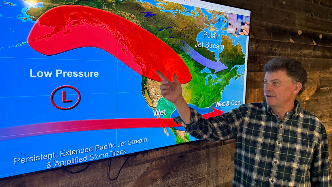
The current buzz is about a “sudden stratospheric warming” occurring over the North Pole, 50,000 to 100,000 feet above the surface, that is warming and expanding the stratosphere. This can push Arctic air south into the U.S. over the next few weeks.
The intense impacts of a polar vortex occur when some of that cold air escapes from the rotating blob. A shift in the vortex's center, aided by the jet stream, can send Arctic air to lower latitudes, where it interacts with whatever’s hanging around in the atmosphere.
Day called it “the gaps in the fence.”
“That’s the best way to describe it,” he said. “When the stratosphere warms, it creates gaps in the fence where the polar vortex can escape and wander, just like cows when you leave the gate open.”
Nobody can anticipate when or where those gaps will occur. Anything in the path of the polar vortex’s escaped air can expect an intense surge of winter weather.
That’s where the timing of this polar vortex, along with the ongoing Super El Niño, becomes crucial.
“Having a polar vortex happen at the end of November or early December is not unusual,” Day said. “Seeing one three weeks earlier is pretty significant, and we’ve never seen this with a Super El Niño.”
Quarterback & Running Back
Day has already called the Super El Niño “the quarterback” for the 2026-2027 winter season. The El Niño-Southern Oscillation in the tropical Pacific Ocean is particularly strong this year, which means it will be the dominant factor for the next several months.
Continuing that analogy, Day called this polar vortex “the running back”: Not the main player, but a significant one.
“We've never seen this with a strong El Nino before,” he said. “If we get all this warm, moist air that is being fed into the southwestern and western United States because of El Nino, and then we throw in something cold coming in from the higher latitude, it's quite the combination.”
This complex interaction could amplify any impacts from the polar vortex disruption, as it has in the past.
“This is how you get deep freezes in Texas,” Day said. “This is how we got the big Arctic outbreak in the Great Lakes last winter. That's what we're anticipating. We just don't know where the gate's going to open or if it's going to wander very far. We don't have a lot of historical precedent for this.”
Myers said cold temperatures are the hallmark of a polar vortex disruption. Increased snowfall is possible, but the moisture must come from elsewhere, usually the Pacific Ocean.
“What we’re generally looking at is cold air,” he said. “If the surrounding setup supports increased moisture at the same time, you could have more snow, but what we’re talking about now is colder temperatures.”
What About Wyoming?
The earliest polar vortex in nearly 70 years is already circulating over the North Pole, but it won't change anything immediately. According to Day, it can take two to four weeks for Arctic air to start escaping.
That puts the window for potentially intense winter weather in the last ten days of November, right around Thanksgiving.
Will any of that impact Wyoming directly? Day isn’t going to speculate beyond “maybe.”
“We're far enough out that we don't know where it's going to go,” he said. “It could hit us, for sure, but it could just as easily miss us. We should not assume anything is going to happen.”
Last winter, the polar vortex collapsed in early December. That sent lots of frigid Arctic air down into the U.S., but not Wyoming.
“The million-dollar question was how far that Arctic air would penetrate into Wyoming,” Day said. “It didn’t.”
If the right gap opened, the Super El Niño could combine with the disruption to bring a windfall of cold air right across Wyoming by the end of November.
November 180
If there’s one word to describe Wyoming’s extended forecast for November, it’s “boring,” Day said.
That makes the potential of the polar vortex more intriguing and potentially concerning.
“There’s really not much going on,” Day said. “It is going to be very boring for the next week to 10 days before we see the potential polar vortex change at the end of the month.”
Day isn’t indulging in hypotheticals, but what could happen if the polar vortex is disrupted and its effects reach Wyoming, alongside the strong pull of El Niño?
“Significant snow and cold, but I don't want to set expectations this far out,” he said. “The other expectation is that it misses us entirely and we stay warm and dry, which is what happened last winter.”
Either way, this polar vortex disruption is worth taking seriously, Day said. Even if its direct impact isn’t severe in Wyoming, it’ll be severe somewhere.
“It might bring colder than normal temperatures to some parts of the U.S., but right now it looks like that's maybe not so much Wyoming and more Alaska and maybe down into the eastern U.S.,” Myers said. “This would be at the end of November, and maybe through December, but it’s not indicating as much for Wyoming as other places.”
Day advised Wyomingites to keep expectations of winter weather low at home while considering what could happen elsewhere. Nobody can anticipate how an early polar vortex will mix with a Super El Niño, but it’s likely to be intense.
“It's way too early to say it's going to be here or Chicago or New York or Seattle, but this is a real wild card,” he said. “
Andrew Rossi can be reached at arossi@cowboystatedaily.com.