
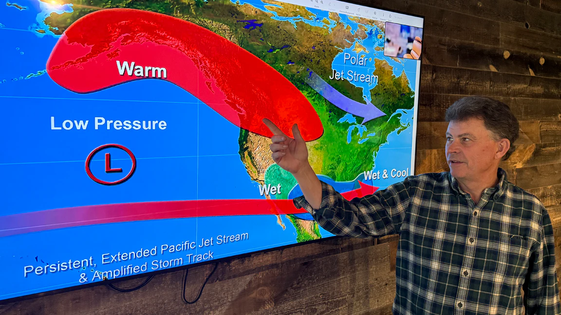
After a “generational winter” that left most of the western U.S. historically dry and the rise of a Super El Niño, Cowboy State Daily meteorologist Don Day is ready to release his 2026-2027 winter forecast.
Day has arduously used the tools at his disposal to project what’s most likely to happen in Wyoming this winter. Uncertainty remains, but he feels confident in his forecast for the next nine months.
“First, and really most importantly, people in Wyoming need to know that this upcoming winter will not play out the same for everybody,” he said. “What will happen in Sheridan this winter is likely going to be different than what happens in Laramie and Cheyenne.”
Day's forecast has good and not-so-good news for those hoping for more snow. Southern Wyoming could get “adequate” snow and precipitation, thanks to El Niño, while northern Wyoming might face “two bad years in a row.”
That’s usually true for most Wyoming winters, but the impacts of El Niño and other factors, like polar vortexes and the jet stream, can’t be underestimated or understood until we're further into the season. El Niño will dominate the next nine months, but its impacts can still shift and rearrange.
Day did have one significant reassurance for all Wyomingites: This winter won't be like last winter.
“What happened last winter is unlikely to happen again this winter,” he said. “We’ve still got some challenges, but a repeat of last winter is not likely.”
The I-70 El Niño
El Niño is the dominant factor for the upcoming winter season. Many agencies, such as NOAA, have been anticipating “one of the strongest El Niños in 50 years” for months.
Day acknowledged that El Niño's impact will be “significant” but not all-encompassing. Using football as an analogy, El Niño will be the quarterback of the winter season.
“El Niño will be the dominant player of the winter season and into the spring season, but it's not the only player on the field,” he said. “We still have the wild cards, high-latitude and stratospheric things, that could play a role in how the winter unfolds.”
The most confident outlooks and models have El Niño settling in over the southern U.S. That’s where its impact will be most profound, radiating outward from there.
This north-south gradient is typical for El Niño. Based on current conditions and long-range weather modeling, Day described this winter as “the I-70 El Niño.”
“I like using west-east interstates to explain the north-south gradient of El Niño,” he said. “It’s a given that I-40 is going to have a very wet spring into summer. With an El Niño this strong, Confidence is moderately high that the moisture patterns that you see with El Niño will get into I-70 as well.”
The “enhanced” impacts of El Niño, meaning above-average precipitation, can reach farther north to I-80 in Wyoming, but that’s on a case-by-case basis.
“No two El Niños are exactly the same,” Day said. “The northern extent of its impacts will vary, but it's very difficult for the heavier precipitation from an El Niño to consistently get much farther north than I-80. Sometimes, the I-90 corridor completely misses it out.”
The north-south gradient of El Niño will have widespread impacts on Wyoming’s winter. While portions of Colorado, Utah, and California get a bounty of winter weather, Wyoming might miss out because it’s too far north.
A Super El Niño might have wide-reaching impacts, but it’s too early to say whether that’ll happen, Day said. The takeaway, according to Day, is that Wyoming won’t get the worst winter weather this season.
“The point is that, historically, you can't find an El Niño that brings all of Wyoming above-average precipitation,” he said. “The farther north you are, the less you're likely to benefit. We can only hope the storms track far enough north that we can benefit from the enhanced precipitation those folks will get down to our south.”
The Three-Phase Winter
Rather than project a broad overview of how Wyoming’s winter could manifest, Day presented his 2026-27 winter forecast in three phases, with three months each.
Based on his analysis, Day said Wyoming could have a “very active” fall and spring, while the three-month winter period could be much less active.
“The middle, between December and February, looks softer, meaning not a lot of weather,” he said. “There’s a historical precedent for this. We've had warmer and drier Decembers with El Niños, historically, and that can extend into January.”
Meanwhile, the first phases – September through November – could have much more weather than an average year. Day said that already seems to be happening.
“We have seen some amazing rain the last couple of days down in southwest Colorado,” he said. “Albuquerque's finally getting a bunch of rain. That's the subtropical moisture that El Niño helps bring in during the fall.”
Day anticipated “a pretty strong likelihood” that a combination of extra El Niño moisture and cold Canadian air could generate a lot more storm activity over the next 2 1/2 months.
The same scenario is likely to play out between March and May, due to the same combination of factors.
“I would say it is more likely to be snow than rain this fall,” Day said. “I don't see it being super cold in October, but I do see it getting colder in November.”
The “soft” midwinter will be the biggest concern in Wyoming. December, January, and February could be very inactive, with little to no significant storms moving across the state.
That's different from what happened last winter. The same nine-month period from September 2025 to May 2025 was universally bad, with below-average precipitation and above-average temperatures.
“Last year, the fall was awful,” Day said. “There was no fall, so there wasn’t any fall moisture to work with going into winter. Then we didn't have any winter moisture to carry us into spring, and spring was spotty and not very good.”
At the very least, Day said the historical precedent for El Niño favors “something on either end of the drier months.” An active fall could carry Wyoming over into an active spring, minimizing a lack of winter weather between December and February.
“The best El Niños I've seen in Wyoming, in terms of bringing the state some needed moisture, tend to be at the end, not at the beginning,’ Day said. “If you get some adequate fall moisture, you can really ride that into that soft period.”
The Northern Hangover
The key to understanding an El Niño winter is the north-south gradient, he said. With a Super El Niño, that gradient could be even more impactful.
Because El Niño’s already setting up over the southern U.S., the most likely region to benefit is southern Wyoming. That’s how Day sees it playing out.
“Being conservative, the pattern looks OK for the North Platte Basin,” he said. “The snowpack that comes out of northern Colorado and southern Wyoming into the North Platte River system has a decent chance for a much better winter than last year.”
The mountains in southwest Wyoming, draining into the Green River Basin, could also do well.
However, the same patterns benefiting southern Wyoming mean the opposite for northern Wyoming. That’s where Day had his biggest snowpack concerns.
“This is not a good pattern for the snowpack coming out of the Bighorns,” he said. “This is not a really good snowpack pattern for the mountains above Cody, the Yellowstone Plateau, and the drainages coming out of Montana.”
Day said northern Wyoming is likely to experience “a hangover” over the next nine months. That doesn’t mean it’ll experience widespread snow drought this winter, but it’ll probably have less snowpack than preferred going into next summer.
“I think northern Wyoming, and into Montana, Idaho, Washington, and Oregon, is likely to have two bad snowpack years in a row,” he said. “That's the biggest concern, based on the modeling and historical precedent.”
The positive in this pessimistic outlook is that an active fall and spring could do a lot to mitigate the hangover, Day said. The next few months will be critical for northern Wyoming.
“It’s important that northern Wyoming gets something over the next three months,” Day said. “If it’s not a wet fall in that region, the December to February phase likely isn’t going to be very productive.”
Not That Cold
Historically, El Niño favors below-average temperatures during Wyoming’s winter. According to Day, that trend will likely continue with the I-70 Super El Niño.
“El Niño moves the jet stream south, allowing colder air masses from Canada easy access to come south into the country,” he said.
Canada is anticipated to have above-average temperatures this winter, but Day reminded Wyomingites that a warmer-than-average winter in Canada is “still cold.”
Even during the soft period between December and February, Day said Wyoming will be “consistently colder” during the winter season.
“It’ll be a little bit colder than average, but not extremely cold,” he said.
The (Potentially) Big Benefit
Day was cautiously optimistic about one widespread impact for Wyoming this winter. Because of the Super El Niño, wind might not be as prevalent this winter.
“Last winter, the jet stream was either to the north or to the east of us, which is the perfect position for windstorms, which we had plenty of,” Day said. “El Niños, with that southern jet stream, historically keep those stronger winds aloft away from us, which will reduce wind events.”
That will also affect the overall temperatures. If it’s not as windy, fewer down-sloping chinooks will develop in the mountains, which will keep Wyoming colder.
“It doesn't mean no wind, but it means less wind,” Day said. “I don’t want to jinx it, but if that jet stream is suppressed to our south, which is looking highly likely that's going to happen, that means much less wind this winter. I don't think anybody is going to complain about that.”
A Phased Approach
Because the El Niño signals are so strong, Day said his confidence in his winter outlook was “higher than average.” That said, there’s plenty that could happen to improve or degrade conditions over the next nine months.
“Going back to my sports analogy, we all know the quarterback runs the offense, but there are wide receivers and running backs that could be a factor,” he said.
One of the “running backs” Day will be watching is the development of an active, robust polar vortex. That could alter the jet stream's southern trajectory.
Day is also concerned about the ongoing impacts of the January 2022 Hunga Tonga–Hunga Haʻapai eruption.
The submarine volcano in the South Pacific sent 150 trillion gallons of water into the stratosphere, a normally dry layer of the atmosphere. Day said this event has and will continue to impact global climate in ways that can’t be factored into long-range weather modeling.
“Those are things that we're watching, and we're concerned about, but they don't necessarily fit in our seasonal modeling,” he said. “That’s why you must take the seasonal models as a guide, but you can't necessarily take them verbatim.”
As everything stands, the 2026-2027 winter season looks to start with a busy fall and transition into a “soft” winter that will lead to a busy spring, Day said.
El Niño will be the ultimate arbiter. That gives Day and other meteorologists high confidence in their long-range forecasts, but nobody’s resting on their laurels.
Future changes in high-latitude conditions are what Day “is going to lose sleep over” between now and May 2027. That’s why he took a phased approach to his long-range forecast.
“Let's see how this first phase goes,” he said. “If these polar vortex situations end up manifesting, it won’t happen until late December and January. Let's see how this first chunk goes, then make another assessment as we go along.”
Andrew Rossi can be reached at arossi@cowboystatedaily.com.


