An Arctic cold front has just arrived in northern Wyoming early Saturday morning and will continue to move south during the day bringing strong north winds, plunging temperatures and rain changing to snow.
The front will be arriving in central Wyoming near Casper by late morning and the southern border by mid to late afternoon.
Temperatures which were in the 60s and 70s in many areas on Friday will only be in the 20s and 30s for Sunday and Monday with wind chills in the single digits and teens.
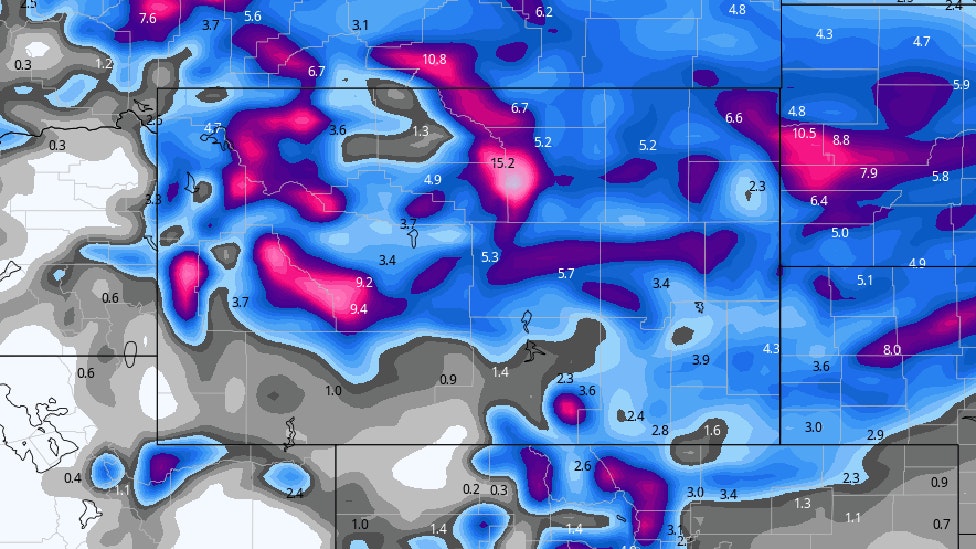
The heaviest snow will be in central, northeast and east central areas of the state. Places like Sheridan, Buffalo, Casper, Douglas, Lusk and Lander can expect 4 to 10 inches of snow by mid day Sunday. Snow will also be very heavy (a foot or more) in the Big Horns, Wind Rivers, Laramie Range, Snowy Range and Sierra Madre mountains. Snowfall totals will be lighter in southeast Wyoming with Laramie and Cheyenne expecting 1 to 3″.
Temperatures Sunday night will dip into the single digits and teens with temperatures remaining very cold through Monday. Below average temperatures are expected for all of next week across the Cowboy State.
Travelers and stock growers should be prepared for harsh winter conditions late today through Monday.


