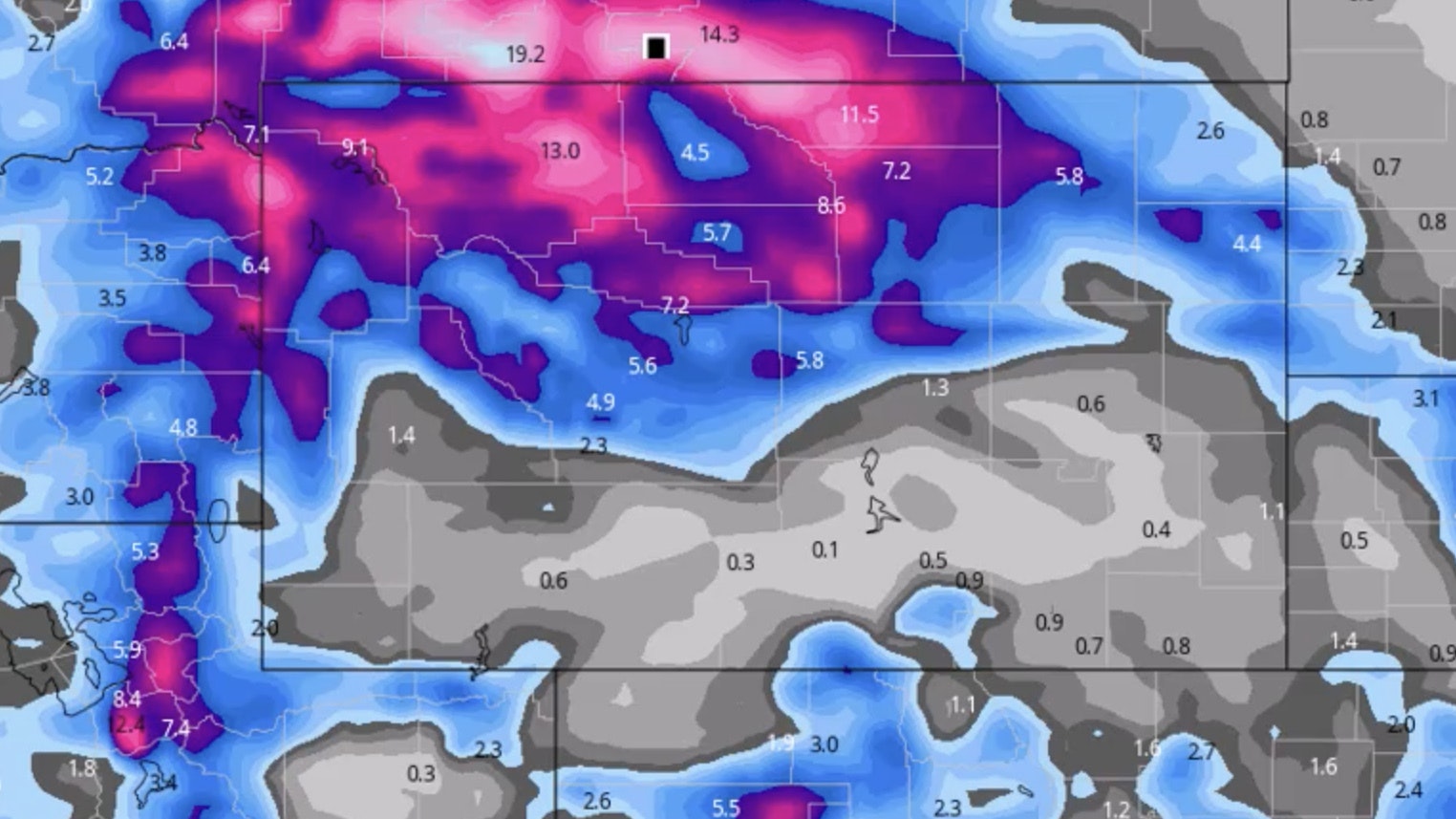
It’s Saturday, March 25 – and “unsettled” is the word for the weekend when it comes to our weather here in the Cowboy State. The weather will be changeable and variable throughout the state. The Pacific wave that is bringing in snow, rain, and even some thunderstorms this weekend will also bring bitter cold in other parts of the state. The small, intense storm that is hitting the northern and central part of the state will drop significant snow, as will the storm that is impacting the southwest corner of Wyoming.
Central:
Snow showers are likely this afternoon in Casper, otherwise cloudy and windy, with a high near 32 and wind gusts as high as 40 mph; new snow accumulation of less than a half inch possible. Riverton could see 2 to 4 inches of snow today, with a high near 29. Snow showers are likely near Jeffrey City this afternoon, although winds will blow the snow around in the morning, with gusts as high as 33 mph; highs near 25, with wind chill values as low as -5 and new snow accumulation of around an inch possible.
Snow showers are likely overnight in Casper (around an inch possible), with a low around 19; breezy, with wind gusts as high as 20 mph. Riverton can expect 1 to 3 inches of new snow tonight, with a low around 13. There’s a 40 percent chance of snow showers tonight in Jeffrey City (less than one inch possible), with a low around 9 and wind chill values as low as -5; breezy, with gusts as high as 24 mph.
Southwest:
There’s a 30 percent chance of snow showers this morning in Evanston, otherwise partly sunny, with a high near 19 and wind chill values as low as -7; new snow accumulation of less than a half inch possible. Rock Springs has a slight chance of snow showers today, otherwise partly sunny, with a high near 27 and wind chill values as low as -5; windy, with gusts as high as 38 mph. Kemmerer could see some isolated snow showers today, otherwise partly sunny, with a high near 24 and wind chill values as low as -10; breezy, with gusts as high as 34 mph.
Mostly cloudy overnight in Evanston, with a low around 1 and wind chill values as low as -13. Partly cloudy tonight in Rock Springs, with a low around 8 and wind chill values as low as -5; breezy, with gusts as high as 31 mph. Mostly cloudy in Kemmerer overnight, with a low around 1 and wind chill values as low as -10; breezy, with gusts as high as 28 mph.
Western Wyoming:
Pinedale can expect scattered snow showers today (less than half an inch possible), with a high near 19 and wind chill values as low as -10; blustery, with gusts as high as 31 mph. Afton could see 1 to 2 inches of new snow today, with a high near 25; breezy, with gusts as high as 21 mph. There’s a 20 percent chance of snow showers today in La Barge, with a high near 21 and wind chill values as low as -5; blustery, with wind gusts as high as 30 mph.
There’s a 20 percent chance of snow showers overnight in Pinedale, with a low around 5 and wind chill values as low as -5; blustery, with gusts as high as 23 mph. Afton has a 50 percent chance of snow showers overnight, with 1 to 2 inches of new snow possible and a low around 10. Mostly cloudy tonight in La Barge, with a low around -1 and wind chill values as low as -10; breezy, with gusts as high as 26 mph.
Northwest:
Snow showers are likely this afternoon in Dubois (less than an inch possible), otherwise cloudy, with a high near 26 and wind chill values as low as zero; breezy, with gusts as high as 31 mph. Jackson can expect less than half an inch of new snow today, with a high near 25; breezy, with gusts as high as 21 mph. WINTER STORM WARNING in Yellowstone National Park, with an inch of snow possible, and a high near 26; blustery, with gusts as high as 23 mph.
There’s a 40 percent chance of snow showers overnight in Dubois (less than half an inch possible), with a low around 13 and wind chill values as low as zero; blustery, with gusts as high as 24 mph. Jackson has a 50 percent chance of snow showers tonight (less than one inch possible), with a low around 12; breezy, with gusts as high as 20 mph. Snow showers are likely tonight in Yellowstone (less than one inch possible), with a low around 16; breezy, with winds gusting as high as 20 mph.
Bighorn Basin:
WINTER STORM WARNING IN EFFECT UNTIL SUNDAY MORNING
Snow showers are likely this morning in Greybull (less than half an inch possible), with a high near 36; breezy, with gusts as high as 31 mph. Thermopolis could see 3 to 7 inches of snow today, with a high near 35; breezy, with gusts as high as 24 mph. 3 to 7 inches of snow could fall in Cody today, with a high near 29; blustery, with gusts as high as 28 mph.
There’s a 50 percent chance of snow showers overnight in Greybull (less than half an inch possible), with a low around 23; breezy, with winds gusting as high as 21 mph. Another 2 to 4 inches of snow could fall overnight in Thermopolis, with a low around 22. Cody could see an additional 1 to 3 inches of snow tonight, with a low around 18; blustery, with gusts as high as 23 mph.
North Central:
WINTER STORM IN EFFECT THROUGH MONDAY EVENING
Sheridan could see around 5 inches of snow today, with a high near 30. 4 inches of snow is expected today in Dayton, with a high near 28. Story can expect around 7 inches of snow today, with a high near 30; breezy, with wind speeds 11 to 20 mph.
2 inches of new snow could fall in Sheridan overnight, with a low around 18. Dayton can expect around an inch of new snow tonight, with a low around 16. 2 inches of new snow is expected overnight in Story, with a low around 18.
Northeast:
Snow is likely in Newcastle this afternoon (less than half an inch possible), with a high near 38 and wind chill values as low as 17. Gillette could see around an inch of snow this afternoon, with a high near 35 and wind chill values as low as 17. There’s a 40 percent chance of snow in Aladdin today, with patchy dense fog expected before noon and a high near 36, with wind chill values as low as 20.
Newcastle could see 1 to 2 inches of snow tonight, with a low around 22 and wind chill values as low as 15. 1 to 3 inches of snow could fall overnight in Gillette, with a low around 23 and wind chill values as low as 14. There’s a 50 percent chance of snow overnight in Aladdin, with a low around 20 and wind chill values as low as 13.
Eastern Plains:
There’s a 50 percent chance of snow in Douglas today, with a high near 35; windy, with gusts as high as 40 mph. Wheatland has a 40 percent chance of snow today, with a high near 35; windy, with gusts as high as 45 mph. Midwest could see 1 to 3 inches of snow this afternoon, with a high near 29; breezy, with gusts as high as 28 mph.
Douglas has a 50 percent chance of snow overnight, with a low around 15; breezy, with gusts as high as 25 mph. There’s a 30 percent chance of snow in Wheatland, with a low around 21; breezy, with gusts as high as 30 mph. Snow showers are likely overnight in Midwest (less than an inch possible), with a low around 19; breezy, with gusts as high as 20 mph.
Southeast:
Laramie has a 40 percent chance of snow today, with a high near 24 and wind chill values between -5 and 5; breezy, with gusts as high as 35 mph. There’s a 40 percent chance of snow today in Cheyenne, otherwise partly sunny and windy, with a high near 29 and gusts as high as 45 mph. There’s a 50 percent chance of snow in Chugwater today, with a high near 31; very windy, with gusts as high as 60 mph.
Laramie has a 30 percent chance of snow this evening, then gradually becoming mostly clear, with a low around 2; breezy, with gusts as high as 30 mph. There’s a 20 percent chance of snow today in Cheyenne, otherwise partly cloudy, with a low around 13; blustery, with gusts as high as 30 mph. Chugwater has a 40 percent chance of snow tonight, with a low around 18; breezy, with gusts as high as 35 mph.
South Central:
There’s a 30 percent chance of snow this afternoon in Saratoga, otherwise partly sunny and windy, with a high near 20 and wind chill values between -5 and 5; wind gusts as high as 35 mph. Rawlins has a 30 percent chance of snow this afternoon, with a high near 22 and wind chill values between -5 and 5; windy, with gusts as high as 40 mph. There’s a 40 percent chance of snow in Hanna today, with a high near 20 and wind chill values between -5 and 5; windy, with gusts as high as 45 mph.
Mostly cloudy tonight in Saratoga, then gradually becoming mostly clear, with a low around -3; breezy, with gusts as high as 30 mph. There’s a 20 percent chance of snow tonight in Rawlins, then gradually becoming mostly clear, with a low around 4 and wind chill values between -5 and zero; breezy, with gusts as high as 35 mph. Hanna has a 20 percent chance of snow tonight, then gradually becoming mostly clear, with a low around 3 and wind chill values between -5 and zero; breezy, with gusts as high as 35 mph.


