Welcome to Wednesday, February, You’re watching the Day weather podcast.
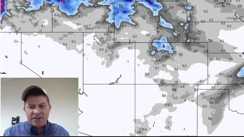
Let’s take a look at the snowfall forecast. Notice we continue to see — not a lot — but a little of snow coming thru the Rockies and the High Plains.
There’s a system coming in today and early Thursday that will spread a little bit of light snow.
You can see while it’s not heavy we are talking about a dusting — one to two inches of snow on the plains east of the Divide. You can see a little bit more snow falling on the mountain ranges as you would expect.
Cold air will continue to funnel in out of Canada. So it’s going to be pretty chill. A little bit of snow, lot a lot of snow but enough to be a nuisance.
It’s still going to make the roads icy across the region. This is especially true across the higher mountain passes of Colorado, I-80, I-25, I-90 across northeastern Wyoming.
We have slick roads just about everywhere due to recent snow events and the fact that it continues to be cold and it will stay cold.
Temps for another day or two will be pretty chilly. They will warm up a little as we get into Friday and Saturday.
Beyond Saturday, we are going to keep our eye on a developing storm system that could come in Sunday into President’s Day Monday.
This is the basic upper level jet stream by Monday morning. Notice there is a trough coming in right here coming into southwestern Wyoming and northeastern Utah.
this chart we’re showing you is from the European model. It is a bit stronger than the American models but it is something we need to watch.
We’ve seen systems like this right around the President’s Day weekend that sometimes show up and comes thru before heading out to the East. So if you have a three day weekend coming up, you’ll want to keep a close eye on the weather. There could be a little more snow in the forecast.
Taking a look 10 days from now. Notice the jet stream flow kinda of straightens out. Low out here on the west coast that meanders around. More in the way of Pacific air coming in.
We talked about this yesterday. After the 20th or so it doesn’t look as cold. But it does look like a busy weather pattern especially as we get to the end of February and the beginning of March.
There’s a lot of winter weather on the table. Nothing too bad for the next few days. But do be ready for cold and just enough snow to be a nuisance.
For folks who follow the Day weather podcast, one thing we talk about is the sun, cosmic rays, solar activity
We are at a solar minimum right now — the strongest solar minimum in over 100 years. One thing that we keep track of is the amount of cosmic rays hitting the Earth.
Right here is where we are right now with cosmic rays. The space age record goes back to 2009 in the last solar minimum. We are really close to breaking this record.
Cosmic rays have been tracked since 1964. So this solar minimum which broke records in 2019 could break the record for the most amount of cosmic rays hitting the Earth here in early 2020.
Why is this important? Solar activity has show to make connection with long term climate and weather trends.
Low solar activity has an impact that can make more clouds on the earth and can make it a little bit cooler.
Something we will continue to watch for you as the solar minimum is currently bottoming out right now over the next two or three months. It is interesting to watch.
Thanks for watching the Day Weather podcast, we will talk to you on Thursday.


