Social media pages from southern Wyoming to western Montana have been filled recently with photos of funnel clouds.
These dangerous-looking phenomena seem to be popping up more frequently this spring in a region not usually known for a lot of tornadic activity. Parts of eastern Wyoming, however, are a different animal where tornadoes are fairly common.
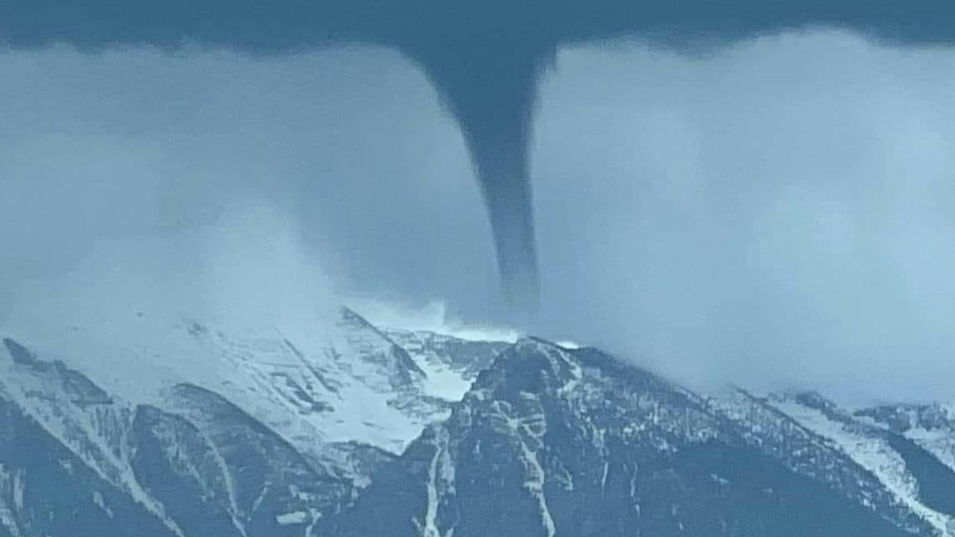
But Cowboy State Daily meteorologist Don Day said what we’ve been seeing here in the Rocky Mountain West aren’t actual tornadoes. These funnel clouds are a different type of wind pattern known as land spouts.
“A land spout is defined as a tornado that does not arise from organized storm scale rotation,” Day said. “So essentially what happens with the land spout is you get a circulation near the ground that is brought into an updraft, that then causes that funnel situation.”
Tornado Vs. Land Spout
Day explained that a tornado forms from the circulation within a thunderstorm itself, whereas a land spout is formed when a thunderstorm connects with a circular wind pattern on the ground, such as the beginnings of a dust devil, and brings it into the updraft.
“A lot of times (land spouts) were just categorized as a weak tornado, but then from further study, they realized that no, they're two different animals,” said Day. “But the appearance, it sure looks like a tornado.”
Day pointed out that there’s a large difference in the intensity of a tornado as compared to a land spout, although land spouts can produce significant windspeeds.
”You can get 70, 80, 90 mph wind gusts in a land spout, so they can certainly cause damage, but they're not going to last very long,” he said. “And they're not going to bring the intensity of the wind and the destructive power of a tornado.”
Additionally, when it comes to land spouts, Day said there’s a larger distance between the base of the clouds and the ground than what’s seen in a tornado.
Spring Phenomenon
Although land spouts can happen in spring and summer, Day said they are visible more often in spring because of the moisture in the air.
“In a land spout situation, the higher humidity air makes it a little bit easier to see the dust and sometimes a little bit of cloud formation,” he said. “A lot of times these land spouts will form later in the summer, but sometimes the air is a little bit too dry, and what will happen is you'll see the dust blowing up on the ground, but you won't see the connection from the ground to the cloud.”
Often, Day said, large dust devils that blow up in the later spring and summer are actually the visible part of a land spout. It’s just too dry to see the connecting formation.
“When we get into July and August, and the ground gets drier, it's hotter and these land spouts continue,” he said. “You might see the dust get stirred up on the ground, and then everybody goes, ‘Oh, that's a dust devil,’ because you don't see that connection above the ground anymore.
“So they do continue through the summer, but they are easier to see in the spring.”
Why So Many This Year?
Although Day said it seems like Wyoming has seen a significantly higher number of land spouts this spring, but that really isn’t the case. Rather, he said, visibility and recorded observations of funnel cloud activity is shared more on social media than in years past.
“There are so many more people out there storm chasing,” said Day. “And they take these videos and these pictures and they go on social media. Everybody's got a camera on their phone. So the perception is there's a big increase, but that’s not really the case.”
However, he did say this spring has seen more turbulent weather patterns than in recent years, which has increased the number of visible land spouts.
“It's been a more wet spring, and we've had a lot more thunderstorms this spring than the last two or three,” said Day.
Where Are the Sirens?
Day said he’s had people ask why land spouts are often spotted in locations where no tornado warnings are in effect.
“Land spouts are difficult to forecast and to detect because the rotation is small, shallow and short-lived, and you really can't see them on radar,” he said. “In a tornado situation, you'll see the circulation in radar inside the thunderstorm.
“But if the rotation is on the surface of the ground, being brought into that updraft, a lot of times it does not have that resolution, so radar detection of these is very, very difficult.”
Look To The Clouds
Additionally, Day said the term “land spout” has been used in weather discussions more often this year because forecasters are educating people about the distinction between those phenomena and actual tornadoes.
“The term ‘land spout’ has been around for quite a while,” he said. “But there is now a recognition that a lot of times what was categorized as a tornado in the past, especially in this part of the country, is more often a land spout.”
When in doubt, Day said, look to the cloud base to determine if the funnel cloud you’re seeing is a land spout or a tornado.
“If the cloud base is close to the ground, and you see what looks like a mezzo cyclone, wall cloud situation, then you've got yourself a tornado,” he said. “And then, if it’s a high cloud base and you see the dust on the ground, it’s a short-lived land spout.”


