Bighorn Canyon is the biggest, baddest canyon in Wyoming at 55 miles long and 2,500 feet at its deepest spot at Bull Elk Ridge.
How could it have taken me 50 years to experience this monster?
I have always loved Wyoming’s canyons.
• Sinks Canyon in Lander.
• Wind River Canyon south of Thermopolis.
• Firehole Canyon south of Rock Springs.
• Shell Canyon east of Greybull.
• Yellowstone Canyon in our great national park.
Is it possible that Bighorn Canyon could match these fabulous monstrous cuts in the mountains for size and grandeur? The answer is a resounding yes.
Way too many Wyoming folks (including me) have not made the long journey north to see this wonder of wonders.
I may have seen it back in the 1970s, but those memories are dim. Seeing Bighorn Canyon with a local authority had been on my Wyoming bucket list for decades, and publisher David Peck finally gave me my first real close-up view last month.

David Peck, at the visitor overlook, shoots photos of the vast Bighorn Canyon. (Bill Sniffin, Cowboy State Daily) 
Three kids are having a thrill bouncing along the waves in the canyon on this day. (Bill Sniffin, Cowboy State Daily) 
The sheer size of Bighorn Canyon can be seen here as the boat with a trailing skier are just specks in the distance. (Courtesy David Peck) 
There's nothing like experiencing Bighorn Canyon on the water. (Bill Sniffin, Cowboy State Daily) 
David Peck was able to get close to a wild horse from the famous Pryor Mountain herd. (Bill Sniffin, Cowboy State Daily) 
There are unique rock formations like this chimney rock along the canyon walls. (Bill Sniffin, Cowboy State Daily) 
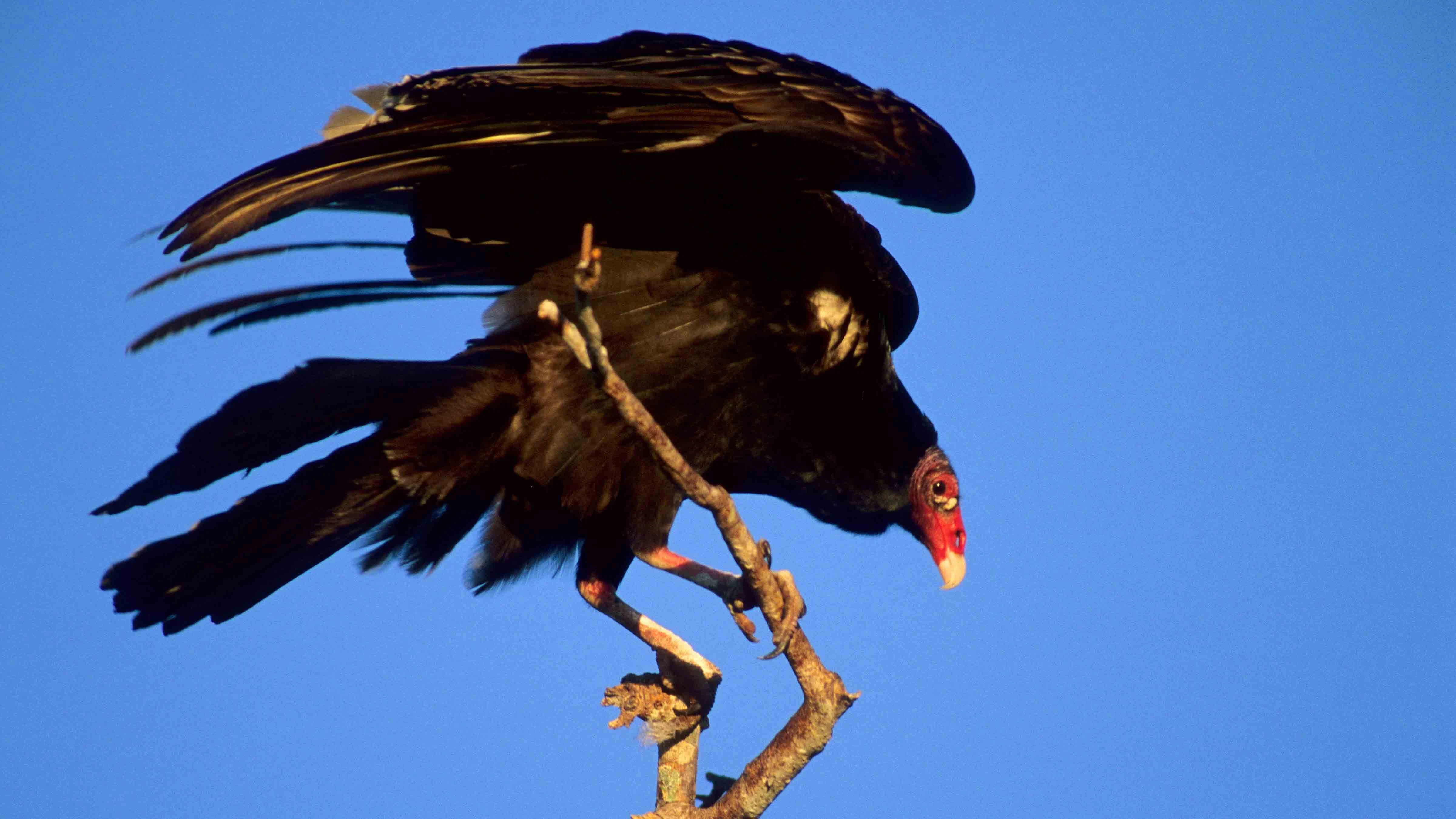
There were many bald eagles perched along the Bighorn Lake. (Courtesy David Peck) 
Jim Minchow of Lovell loves boating on the 70-mile-long lake near his hometown. (Bill Sniffin, Cowboy State Daily) 
This small group of Bighorn Sheep along the road in the Bighorn Canyon National Recreation Area near Lovell. (Bill Sniffin, Cowboy State Daily) 
Cowboy State Daily’s Bill Sniffin enjoyed the boat ride on Bighorn Lake. (Bill Sniffin, Cowboy State Daily)
Bighorn Canyon
It is obvious that Bighorn Canyon carves one of the most dramatic landscapes in the American West, yet remains one of its least crowded destinations.
Tucked along the northern border of Wyoming stretching into southern Montana, it is a place of steep limestone cliffs, sprawling desert plateaus, deep green waters, and evidence of cultures that have called it home for thousands of years.
Bighorn Canyon is a world where geologic time is displayed in every towering wall and winding bend of the river.
With David at the wheel, we were off.
First, you drive east and then north from Lovell where the land seems ordinary at first — sagebrush plains, wind-scoured buttes and pronghorn grazing along the highway.
The famous Pryor Mountain Wild Horses are abundant in the area. We saw several small bunches. They were quite tame and would hang along the highway grazing.
Just beyond the town, the earth seems to open.
The Bighorn River, which begins far to the south in the Wind River Mountains near Dubois, has spent millions of years carving its way through limestone and sandstone layers, creating a canyon that plunges more than 1,000 feet deep in places, and much deeper at others.
The highway into the Bighorn Canyon National Recreation Area passes the very well-appointed Cal Taggart Visitor Center.
Taggart was a visionary Wyoming legislator who promoted the Bighorn Basin like no other.
Unlike Yellowstone or Grand Teton national parks, there are no long lines of RVs or crush of tourists with cameras dangling from their necks. The canyon feels like Wyoming’s secret, a place many lifelong residents have never seen.
First Sight Of The Canyon
At the first overlook, the land drops away so suddenly that it takes your breath away.
The Bighorn River lies below, wide and green, dammed in the 1960s by the construction of Yellowtail Dam.
The dam created Bighorn Lake, a 70-mile-long ribbon of water that snakes through the canyon’s twists and turns. From above, the water looks deceptively calm, but closer inspection reveals the river’s restless spirit.
The cliffs rise sheer on both sides, glowing in shades of cream, rose and ochre depending on the angle of the sun. Bald eagles, turkey buzzards, and peregrine falcons soar in the updrafts. Bighorn sheep scamper along the cliffs.
Bighorn Canyon is a geologist’s dream. The walls are a vertical timeline of Earth’s history.
The oldest rocks near the bottom are more than 500 million years old, laid down in shallow seas when the area that would become Wyoming was closer to the equator.
Above them lie younger sandstones and limestones, shaped when deserts rolled across the land or when inland seas returned.
Standing at the rim, one feels small — not just in scale, but in geologic time.
For centuries, the Bighorn Canyon region was home to the Crow people.
They knew it as a sacred landscape, rich in game and steeped in meaning. The canyon walls still hold petroglyphs and pictographs that speak to their presence.
The Coming Of The Dam
The canyon was forever changed in 1965 with the completion of Yellowtail Dam, named after Crow leader Robert Yellowtail.
The damming of the Bighorn River created not only the deep reservoir of Bighorn Lake, but also the Bighorn Canyon National Recreation Area.
For some, the lake is a playground. Fishermen come for walleye and trout, boaters explore the twisting narrows where canyon walls rise almost vertically from the water.
The canyon has a raw majesty. The water now mirrors the cliffs, doubling their drama, and the quiet coves invite a kind of reflection that feels timeless.
Wind River, Bighorn River
The river system that made Bighorn Canyon is one of Wyoming’s great naming mysteries.
South of Wind River Canyon, the river is known as the Wind River, namesake of the Wind River Mountains, the Wind River Basin, and the majestic canyon I drove through that morning headed north to meet with David.
North of Wind River Canyon at Thermopolis, this beautiful river turns into the Bighorn River, home of the Bighorn Basin and namesake of a giant mountain range and the big canyon.
Yet it is all the same river.
Courtesy of David’s friend Jim Minchow, a scenic boat ride through the canyon was an experience to remember.
The weather was perfect, and those canyon walls were just so towering. Depth of the reservoir ranges from 450 feet at the dam in Montana to about 100 feet in most boating areas.
Flaming Gorge’s canyons far south over 400 miles away are awe-inspiring, but these are closer, making them feel bigger and more like the Grand Canyon.
Thanks to David and Susan Peck and the Minchow family. I would recommend all Wyoming residents to make this trip. What a wonderland!
Bill Sniffin can be reached at: Bill@CowboyStateDaily.com