A 7-mile ribbon of black, charred ground now stands between the Elk Fire and Bighorn Mountain communities to the east, stretching from Goose Creek all the way down to the Red Grade Road, where the Rocky Mountain Area Complex Incident Management Team is building a “catcher’s mitt” for a fireball.
The idea behind the catcher’s mitt is to deprive the Elk Fire of fuel to continue its southward march, forcing the fire to turn back in on itself, away from the communities that lie at the foot of the Bighorn Mountains and stopping its southern trek.
Seen from above, the ribbon of black feels impossibly tiny for the job. But it is one-half to three-quarters of a mile wide for that entire 7-mile stretch, burned one careful block at a time.
Dozer cuts and retardant are also interwoven with the ribbon of black. These were firebreak lines laid down ahead of the intentional burns, outlining jagged jigsaw puzzle pieces set for burning.
The zone buys firefighters time, Rocky Mountain Area team’s spokesman Mike De Fries told Cowboy State Daily Monday night. Time to respond wherever the fire and wind decide to run.
“There are many, many different little drainages, little river drainages that come in from the other side of this mountain range and this terrain,” he explained. “And all of them are potential access points for any southwest wind or west wind to blow the fire this way.”
De Fries’ hands sweep out to include a picturesque landscape below, cut with farmland and trees, cradling the tiny communities of Big Horn, Story and Beckton, off in the distance.
They seem far away. But everyone remembers that Friday night when wind fueled a fire, growing it over night by miles instead of just acres.
Buying Time To Beat Fire And Wind
Time is the thing that is both endless and in short supply with the Elk Fire.
For those breathing smoke daily and for those working 16-hour days on the mountain to boot, time feels endless. Ask anyone in Dayton, Parkman, Story, Big Horn, Beckton, or anywhere in between. These have been grueling days.
But time is also short for the tasks at hand — felling all the large trees that lined Red Grade Road and widening the strip of dirt that lies at points between a sheer vertical slope. And preparing homes in communities to be defensible, as some volunteers helped senior citizens do over the weekend in Story.
Red Grade Road is where the Rocky Mountain Area team has decided the first, most defensible black line lies.
But it is not without considerable challenges, even so.
“It’s like where do we take a stand against the fire?” De Fries said, gesturing toward the Bighorn Mountains. They are beautiful. Lofty and picturesque.
But not a safe place to try and place firefighters, with their sometimes 45-degree slopes, punctuated by unforgiving toe-stubbers and knee-knockers — rocks, brush and tree roots, waiting to trip a firefighter in a hurry to escape.
“There’s no good opportunities (out there),” De Fries said. “Where the fire is burning, in that terrain, and because of the fuels and how they behave, it’s not safe, and it’s not even effective to try to put fire line up in the terrain where a lot of the fire is.”
Retardant isn’t a magic bullet. It can slow a fire down, but it can’t stop a really intense fire from chewing through the available fuel. That’s why the interior of the forest isn’t a good choice. Too much fuel, too intense of fire.

A dozer line stretching from Red Grade Road to the ridge. (Renee Jean, Cowboy State Daily) 
Bernie Bornong, Division Hotel supervisor, after a long day working along Red Grade Road. (Renee Jean, Cowboy State Daily) 
The burned strip of land seen from above stretches 7 miles from Goose Creek down to Red Grade Road. It's between one-half to three-quarters of a mile wide. (Renee Jean, Cowboy State Daily) 
Fire hoses have been laid in strategic locations, while trees and vegetation are being removed from this hillside, which is steeper than it looks. It's around 45 degrees. (Renee Jean, Cowboy State Daily) 
This particular piece of equipment is used to drag downed trees a safe distance from the containment area. (Renee Jean, Cowboy State Daily) 
The feller buncher. It grabs a tree with the mechanical arms, cutting it at the base. Then it lifts the tree and whirls it around, before laying it down on a pile of its fellows. (Renee Jean, Cowboy State Daily) 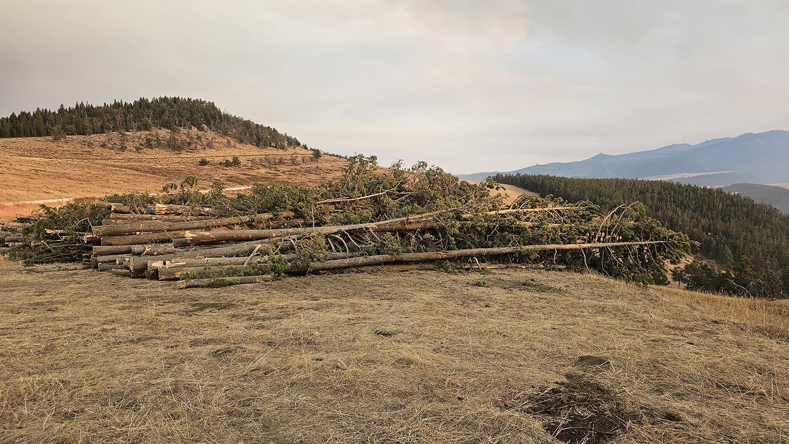
Trees that used to line Red Grade Road lying on their side outside the containment area. Eventually, the limbs will be stripped and the logs offered for sale. (Renee Jean, Cowboy State Daily)
The Forest Looks Like The Planet Vulcan
The 7-mile ribbon from Goose Creek down to Red Grade Road is one-half of the turn that makes the catcher’s mitt.
“This was all done in blocks,” De Fries said, gesturing at the blackened area. “They used dozers to create a line, and they made a block, maybe two-tenths of a mile, and then a rectangular shape, sometimes depending on the terrain for the shape.”
Those blocks were then ignited by hand or sometimes by pinpoint “dragon egg” drops using a drone.
That was possible thanks to better than average weather for the task, De Fries added.
“We’ve had light wind for the most part, not too humid,” he said. “And so they did this 7 miles in a handful of days.”
The other half of the catcher’s mitt will be the Red Grade Road itself, and that’s where the focus has moved. The road, while closed to the public, has been a beehive of activity.
Heavy machineries are regrading the road, widening it, while feller bunchers are working to take out all of the pine trees that once lined the road.
The trees were beautiful, but they were also the perfect bridge for the Elk Fire to continue its southward march, so they had to go.
The feller buncher makes short work of each tree. Mechanical arms hug the tree while a saw at the bottom cuts its base. In seconds, the tree is floating in the feller buncher’s arms. It’s like a swing dance in the air. The arms twirl the tree around then lay it down, ever so gently, with its brethren in a pile.
Eventually, when there’s time, these downed trees will all be stripped of limbs and logged, then offered for sale. For now, they rest just outside where the containment lines have already been cut and drawn with dozer lines and red retardant.
The retardant has colored the earth red, like iron oxide, and left the grass pink. It looks like the set of Vulcan on Star Trek. But these are areas that can readily be fired when the time is right. For now, though, the fire is further off and it hasn’t reached any trigger points yet.
“They will implement a strategic firing plan only when necessary,” De Fries said Tuesday morning. “That’s not something that’s planned for (Tuesday). There will be some firing operations for other parts of the fire up to the north. They’re looking to remove fuel from the northwest edge of the fire, in a location where they think they can create a containment line.”

Road widening activities are taking place along Red Grade Road. Defensible safety zones are also being created. (Renee Jean, Cowboy State Daily) 
A dozer line stretching from Red Grade Road to the ridge. (Renee Jean, Cowboy State Daily) 
Mike De Fries gestures toward Big Horn as he talks about the Elk Fire preparations along Red Grade Road. (Renee Jean, Cowboy State Daily) 
This is what's called a skidgen. It's an all-around firefighting tool. It holds some water, and it can be used to grade roads. (Renee Jean, Cowboy State Daily) 
More portable ponds set up on a hillside near a home. (Renee Jean, Cowboy State Daily) 
This trail head is now serving as a gathering spot for firefighters working along Red Grade Road. (Renee Jean, Cowboy State Daily)
Another Spike Camp Appears
A new “spike camp” has appeared on the southern end of the fire, which started up a couple of days ago.
Spike camps are spinoffs of the main camp. They happen any time a large number of firefighters are working in a particular area for an extended period of time that’s far from the main camp.
Spike camps get supplies from the main camp and include many of the same things as the main camp, including climate-controlled sleeping trailers.
The south spike camp is the second for the Elk Fire. The first was at Antelope Butte, strategically placed for structure protection work taking place at Burgess Junction, west of the Elk Fire.
“When we start to have travel times of 45 minutes to an hour for a significant number of firefighters, we look at where can we put a spike camp,” Rocky Mountain Area’s Field Operations Chief Adam Ziegler has told Cowboy State Daily.
Tuesday’s plan includes continued work in the Red Grade Road area, widening that future containment line ahead of the Elk Fire’s arrival, De Fries said.
This work includes hand digging “check lines,” whose purpose is to slow down the fire, buying more time to prepare Red Grade Road and potentially taking steam out of the fire.
“That’s not at a location where we can safely and effectively stop the fire,” DeFries said. “It’s what we call a slowing action. The fire will continue to move south from there.”
Residents in the communities lying east of the Elk Fire are likely to see a lot of smoke today, De Fries added. That’s mostly due to the weather conditions, which is boosting the fire’s activity.
With the black line now stretching all the way to Red Grade Road, firefighters are ready for any breakout attempts the wind might push, De Fries said.
Some evacuation statuses have been downgraded. Residents southwest of Dayton near Horseshoe Road, for example, have gone from a status of “Go” to one of “Set,” and may now return to their homes.
Some of the roads near Dayton, Parkman and Sheridan have been reopened to the public. Complete information about evacuation status and road closures is available at the Sheridan County Emergency Management website.
Renée Jean can be reached at renee@cowboystatedaily.com.