By Renée Jean, Business and Tourism Reporter
renee@cowboystatedaiily.com
Some days Chance Johnson feels like he’s working for mission control at NASA. That’s because he works surrounded by computer screens all day long, 10 of them at his own station, each one with an absolutely critical function.
If that sounds like a lot to track, it is. But, Johnson said, when one screen goes down, he definitely notices.
“It’s like crap, I guess I needed (all 10) screens after all,” he said. “It seems like a lot until you start doing this a lot. You can see how many tools I have open on every screen. Even then, it can get pretty jumbled.”
All Eyes On Wyoming
Johnson and his crew are the eyes in the sky over Wyoming.
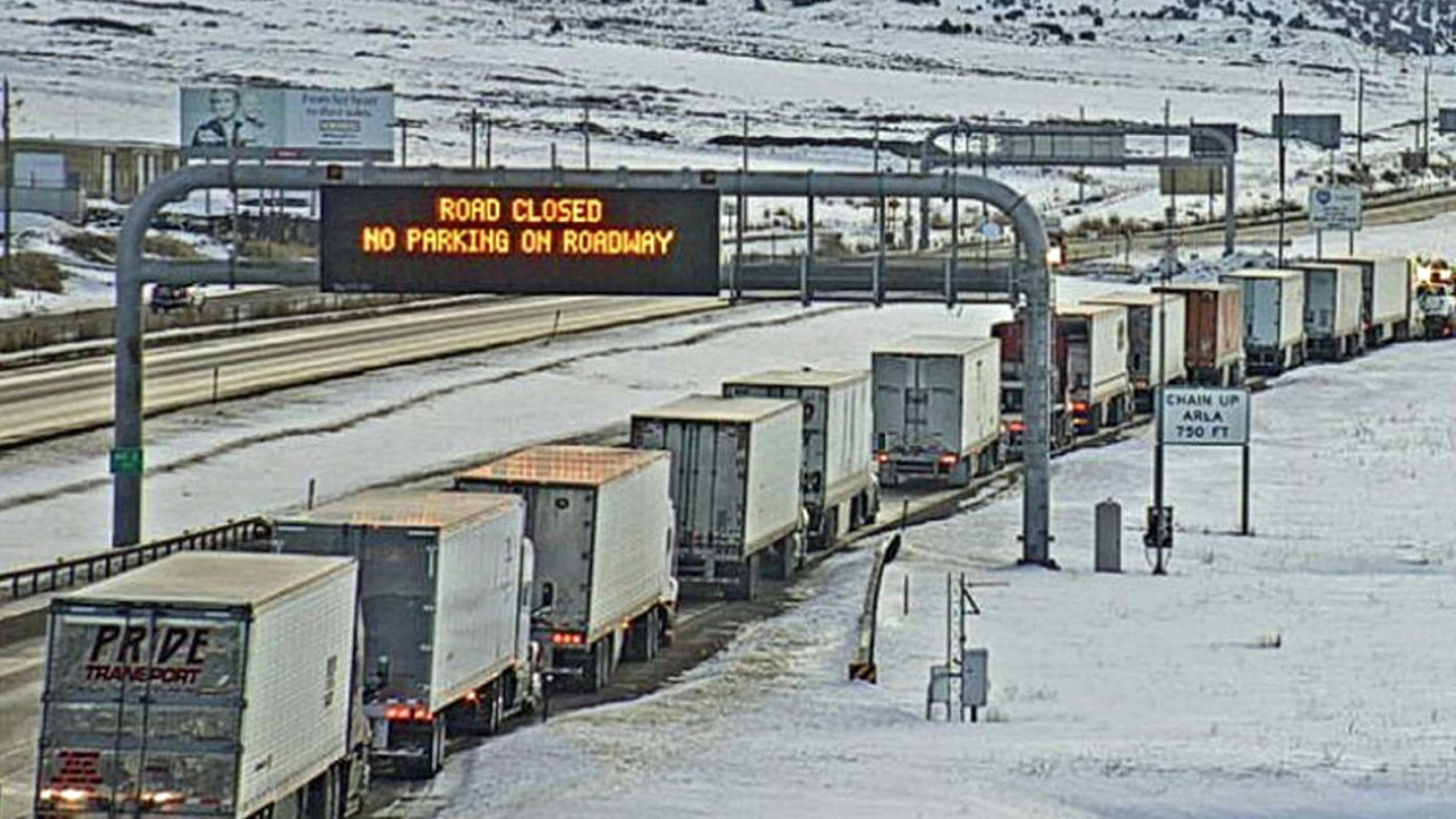
They keep the state’s system of dynamic safety messages up to date across multiple platforms, including 20 highway advisory radios, 162 direct message boards floating above highways in the state, 212 variable speed limit signs in 125 locations and the 511 mobile app.
The system also is supported by 232 remote web cameras and 155 remote weather sensors distributed across the Cowboy State, which all feed necessary information into the system, along with real-time reports from motorists, snowplow drivers, and emergency responders.
Feast Or Famine
On days like Monday, things are relatively slow with not much weather going on across the state. But on days like Wednesday of last week, when a foot or more of snow was dumped on many areas across the state, Johnson admits it can get “pretty chaotic.”
“When it’s slow, we just have a couple of people in here, and any one of them can take over any district from a radio perspective and a technology perspective,” Johnson said.
But when the weather is bad, every station for each highway district will have someone manning a similar set of 10 computer monitors.
Each station in that case is monitored 24/7 so that message boards say what they need to say — even at 3 a.m. — in the most remote areas. This includes making sure road closures happen the instant they need to. Some of the highway arms will even drop down over the road remotely.
That operation is watched using web cameras to ensure that the arm really went down across the road like it was supposed to.
Watching All Day Long
“We kind of monitor the weather all day long, using a variety of methods,” Johnson said. “We’ve got our weather sensors here for all five districts. This will give us everything: surface data, atmospheric data, wind gusts, wind averages, visibility, any precip, or anything like that.”
Radar projections show up on another screen, so Johnson and the team can constantly check whether more snow might show up in an area, but there also are cameras that show what’s going on in real time, in case something moves in under the radar.
“We’re monitoring the cameras pretty much constantly to make sure nothing moves in unexpectedly,” Johnson said.
Automobile crashes and other highway incidents are tracked by a text feed on another screen, which is remotely connected to the Wyoming Highway Patrol.
The feed is a basic outline of what’s happening so Johnson’s team can act on it immediately, without having to call the patrol for details while they are in the midst of handling things.
“That’s pretty useful,” Johnson said. “Going over to our (direct message) signs here, if we have to send something out, it’s a pretty easy system. You literally just select the sign you want.”
After selecting the particular sign, or group of signs, a form comes up with various parameters to set, including a text box for a message.
“We literally just type in here, then hit send, and that is immediately deployed to the field,” Johnson said.
Setting New Speed Limits Is Easy
New speed limits on the state’s variable speed limit signs are set much the same way.
“When an operator gets a change, or a change needs to be made, they have just a dropdown with all the accepted speeds for that VSL,” Johnson said. “They’ll set that selected speed in there. And as soon as they hit send on this, it automatically updates that in the field.”
On another monitor, there’s a live map, similar to the one the public sees, but this one contains the location of each and every working snowplow.
“This is where you’ll see our road conditions change as they’re being changed in the WTI,” Johnson said. “So, if we get a call for a road condition, they’ll come into our crew, and we run on eight, nine codes, eight being surface codes and nine being atmospheric codes.”
One Code Changes All
The codes given by the maintenance unit or trooper to Johnson’s crew are pre-programmed by the system to change up road sections on the map and show that new condition right away.
“For instance, this one here, 202687 drive strong winds 8194. So that goes through immediately,” Johnson said, demonstrating on his system how a few clicks of keys changes the map everyone will see.
That code doesn’t only update the map, however. It also updates the state’s mobile app for email and text alerts and its highway advisory radios, all in one go.
A radio console keeps Johnson’s crew connected to all the districts across the state.
“Four of them are on automatically, and then the operator can kind of tailor it to what they need specifically, as far as crew channels,” Johnson said.
There also are DOT-restricted channels for larger events as well as a connection to the National Weather Service to ask for spot forecasts.
“They usually answer right away,” Johnson said. “We can also get in here to the radio districts for highway patrol and kind of just listen in on what’s going on on their side. So ideally, we can just hear what’s happening without having to check with them every five minutes.”
More Screens Than Ever
Behind Johnson, meanwhile, there’s a dozen or more screens on a far wall, positioned so everyone on the crew can see by just glancing over at them. Each one shows a different highway or biway from across the state. There’s even one with a bird’s-eye view of Jackson skiers frolicking in the snow.
“The screens on the wall are more for the patrol to kind of glance over here,” Johnson said.
The Highway Patrol is co-located with the Transportation Message Center.
Direct message signs became part of the state’s landscape in 2003.
“Cheyenne to Laramie gets some really bad weather conditions, so that was the first ITS project,” Intelligent Transportation Systems Program Manager Vince Garcia told Cowboy State Daily.
Injury crashes have gone down since going to this type of system, added TMC Supervisor Kevin Cox.
“With our variable speed limits, I’ve done some studies on those,” he said. “Injury crashes in particular have gone down pretty dramatically in those variable speed limit zones.”
Trying to measure fatalities is a little harder, Cox said.
“We don’t really have a ton of fatalities in any one spot all the time,” he said. “So, it’s a small statistical number.”
That makes it hard to compare one year to the next.


