The following is a transcript of the special weather update by meteorologist Don Day.
As we take a look at what happened overnight and early this morning, basically we have no significant changes.
There has been a slight southward shift to the storm. Just a slight one, but it’s all coming together, as expected.
We’ve already had wind gusts of 66 miles an hour with heavy snow around Buffalo, Wyoming this morning.
Blizzard conditions will continue for northeastern Wyoming, southeast Montana, up the western side of North Dakota, and far western South Dakota.
Now the heavy rain and snow is gonna get a little bit further south into central and east-central Wyoming and the Northern Panhandle.
So with that southward shift some of the heavier snow a little bit further south and the wind is going to be bad with this system. Winds are going to ramp up over central northern and eastern Wyoming, southeastern Montana, the western Dakotas, western Nebraska, and the far northern parts of Colorado.
That’s going to just make for some very windy conditions with this heavy wet spring snow and that’s why the worst of it will be up in those areas that is listed.
Now I do have a little bit of good news. Some of those thunderstorms that developed last night did bring rain to a few not many but a few areas of Kansas and Nebraska that really needed it last night.
Satellite photos shows just a classic spring storm. You can see the circulation, the counterclockwise circulation around the low as it gets formed.
This brighter cloud band here are the thunderstorms developing up here.
But as we discussed in earlier podcasts, the flow of moisture is coming right up into the backside of the storm coming up from the south so the storm is well formed and really coming together and maturing.
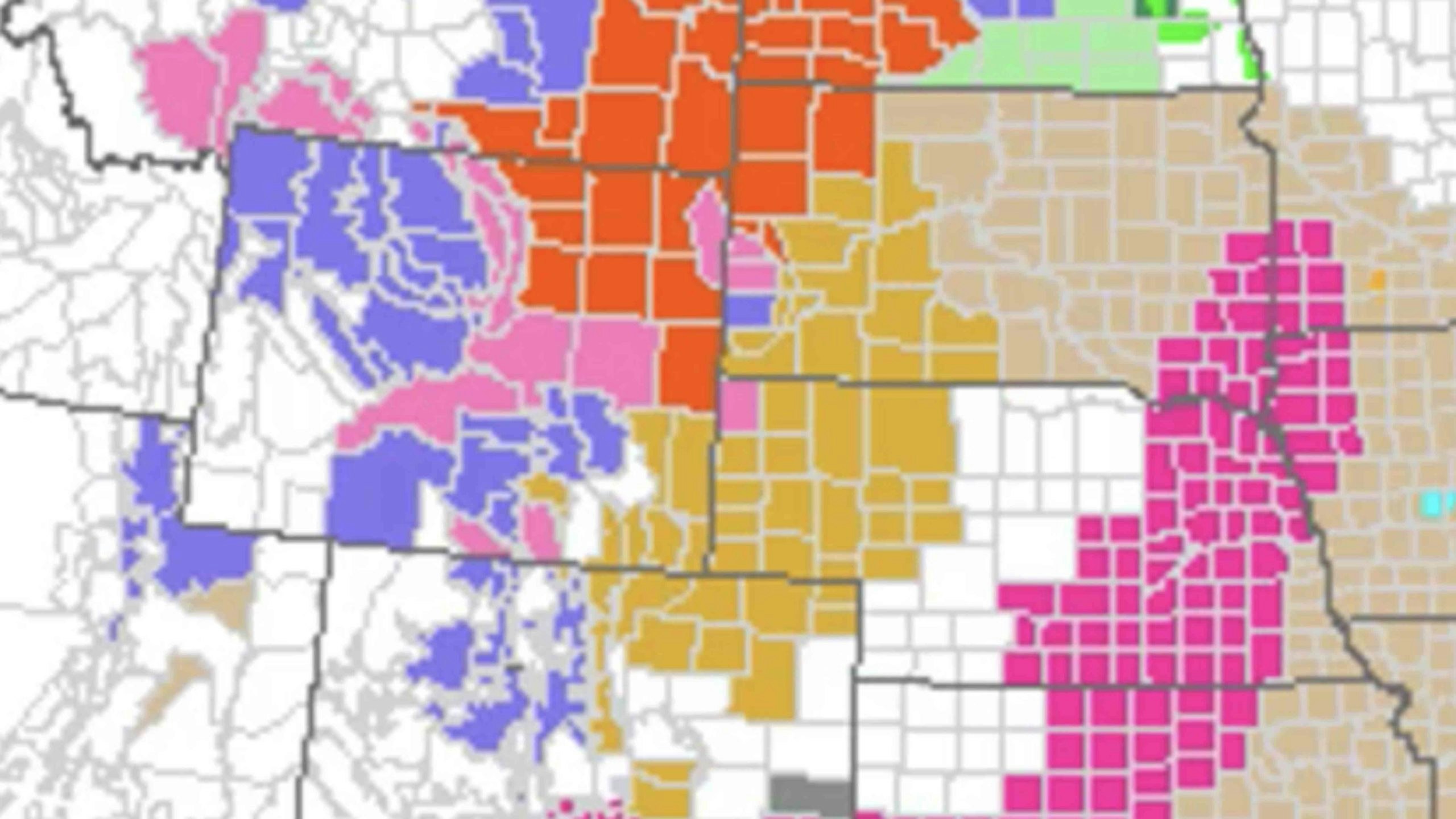
This is the latest update of winter weather advisories: The red is the blizzard warning. The blue winter storm warnings and winter weather advisories. The brown here is advisories for strong winds, high fire danger in this area here flooding here, everything but the kitchen sink and we’ll have severe weather out in the plains with this system later on.
The low surface low is now over south central areas of South Dakota. And you can see how many black lines here, isobars very strong wind gradient wrapping around the backside here.
So this is why we’re gonna have a lot of wind with the snow. The storm is going to move fairly quickly this way later today and tonight, but you can see how large it is.
The large area of the storm is going to affect areas through today tonight into early tomorrow. Radar shows it very nicely. You may notice the hole here. Why is it not showing anything there?
Well, not a really good time for the Rapid City radar to go down but that’s why no radar but there’s plenty going on here. Trust me, the radar just off right now.
Here’s the latest forecast through tomorrow afternoon. So you can see the heavier precipitation in the areas we expected it but notice that little southward shift so that heavier moisture getting a little further south was not going to make anybody unhappy down here that really really needs the moisture but again, you get down to the Cheyenne area, northeastern Colorado, it’s a down slope there.
As we have talked very good snow will be falling in the mountain ranges throughout the course of the day on the backside of this storm as well.
But by far you can see the yellow and the oranges here. This is where the heaviest snow will be with the heaviest wind and you can see it right there.
This is where the heavier snow will fall and there’s that little southern push right there.
Last night I want to show you some cool satellite photos. This is from yesterday evening and you can see on the high resolution satellite an area of thunderstorms here in southwest Kansas.
An area of thunderstorms developing here in parts of north central Nebraska thunderstorms up here in South Dakota as well.
As the storm came over the divide yesterday evening. We did have some strong thunderstorms develop. Here’s I-70 in Colorado into western Kansas. Here’s Goodland, Kansas so you can see there was some needed rain that fell in winter wheat country with those thunderstorms last night.
Then those then move north into Nebraska. So the thunderstorms on the front end of the system did produce some needed rain last night but these areas still desperately need a lot more.
Thanks for watching. Have yourself a good weekend. We’ll talk to you with the regular podcast on Monday.


