Wyoming’s weatherman Don Day on Saturday morning said nothing has changed and the much-anticipated winter storm to affect large portions of the state is on track.
Day, in special edition of his daily weather podcast, said although the bullseye of the storm is in east-central and southeastern Wyoming, other parts of the state from Green River to Lander to the I-90 corridor will be affected as well.
“We went through a checklist earlier in the week where you had to have all the right things come together, all the right pieces of the puzzle to have a really big storm like what’s been being advertised this weekend. All of that’s coming together,” Day said.
In the bullseye areas, two or more feet of snow can be expected while his maps show areas outside of the bulleye to receive anywhere from eight to 21 inches.
“Look at Nebraska and east central and southeastern Wyoming and the Front Range of Colorado, there’s going to be a tremendous amount of water available,” Day said pointing to his maps.
And that’s not at all. Wind is going to be a factor too.
Wind gusts of more than 50mph are forecast in the bullseye areas of southeastern Wyoming, east-central Wyoming, western Nebraska, and northeastern Colorado.
Day cautioned people not to get complacent just because it’s relatively calm on Saturday morning – at the time of his recording.
“Even though there’s really not much going on right now at the time of this podcast here Saturday morning, things deteriorate extremely rapidly in these situations,” he said.
“So things can change on you, don’t test your luck, if you’re gonna go out and drive a long way, hoping to beat it. Because this system is coming together,” he said.
What’s interesting about this storm is that nearly its entire lifespan will happen right here in Wyoming, Colorado, and Nebraska.
“This is typical in these high plains Rocky Mountain big snowstorms is that the storm actually goes through its whole lifecycle right on top of us,” Day said.
“And that’s where you tend to get these big, big snow events. As the storm develops, goes through its whole maturity process. It gets really strong and then it begins to dry out and dissipate as that dry wedge gets pulled in and very typical for that to happen,” he said.
The video of Day’s podcast can be viewed here.
The rough transcription of Day’s podcast follows:
——————————————-
Good morning, and welcome to Saturday, March 13 2021. Here’s a special weather update podcast for everybody. Thought we would get up this Saturday morning and see if the overnight hours would change our mind on the storm.
Well, they didn’t. This is going to happen, folks.
As we discussed yesterday, confidence was getting really high, our computer modeling was was getting lined up being very consistent.
And we went through a checklist earlier in the week where you had to have all the right things come together, all the right pieces of the puzzle to have a really big storm like what’s been being advertised this weekend. All of that’s coming together.
This is a parent based on all the latest information. Southeast and east central Wyoming and western Nebraska and Northern Colorado will be in the bullseye of this storm.
That’s where the heaviest snow is going to fall in those areas along I 25 and Interstate 80. Out further on the plains, it will be a major winter storm as well.
But there’ll be rain at first and that’ll cut off some of the heavier snowfall amounts.
Now for you folks like that i 90 corridor, you remain on the far northern edges of the storm and if the storm wiggles a little more north, you’re going to get into the snow, if it stays on its current track or goes a little more south, you’re just going to get brushed by it.
The I 90 corridor is kind of the boundary of where this storm is going to be impactful. The worst conditions will be Saturday afternoon through early Monday, that’s when everything comes together.
Now a lot of areas are in some freezing drizzle and fog this morning. So we’ve got a thin glaze of ice in many areas east of the divide this morning and East in the mountains.
That’s going to put a thick layer of ice in some areas with this, which is snow is going to fall on top of.
High impacts: obviously for travel and livestock through Monday, this is a dangerous storm. Don’t mess with it.
Even though there’s really not much going on right now at the time of this podcast here Saturday morning, things deteriorate extremely rapidly in these situations.
So things can change on you, don’t test your luck, if you’re gonna go out and drive a long way, hoping to beat it. Because this system is coming together.
As of this morning, the upper level low was about where all the models have been forecasting it to be just north of Page Arizona, drifting very slowly to the four corners area.
And that’s where it is this morning. It remains cut off from the main jet stream, it’s extremely well organized, a high pressure in the Gulf of Mexico.
All of those pieces we’ve been showing you throughout the week have not changed. They’re all there. So the flow of moisture from the Gulf of Mexico was coming.
Now here is a satellite and radar image. This is a radar image just taken. So you can see actually see this ring of moisture. It’s right around the upper level low right here near Lake Powell.
And here’s that fetch of moisture coming up from the Gulf and all over the eastern plains and into here.
Over the last couple of hours, we’ve had lightning strikes in northeastern Colorado and Southeast Colorado in northeastern New Mexico seeing some thunderstorms.
So the instability of the lifting of the atmosphere from the low here is happening as advertised.
Now this moistures got to get drawn in and pulled up here like this. And that’s going to be happening over the next six hours.
As we get into Sunday. This is for noon, Sunday, the upper level low is in southeastern areas of Colorado, very well formed low, extremely deep upslope winds to 30,000 feet getting driven into the northern Front Range of Colorado, southern Wyoming and into western Nebraska.
And the feed of moisture is uninhibited. Yes, there’s going to be some thunderstorms, and that will take away some of the moisture, but the moisture is thick and deep. So even with thunderstorms, we’re still gonna have a lot brought back to the Front Range.
This system here will act as a kicker. So the storm will get pulled out of the area, beginning very late Sunday night into Monday morning.
So this is really going to be about a 42 to 48 hour event all together.
When you take a look at where the surface low pressure will be. It’s going to be right in the southeast Colorado, Oklahoma, Texas Panhandle area right here.
And this is a pressure gradient. These are surface pressures. And you can see the lineup of the surface pressures from west to east here.
And that’s where the wind follows. So the upslope is very, very deep at the surface all the way up to basically where you fly in a commercial jet really high into the atmosphere.
And if you just imagine the amount of lift that takes place, from the moisture that’s brought from the gulf and the planes that are much lower and altitude and lift it to our higher altitudes here that just generates a lot of lift and a lot of the right physics to create snowflakes to cause precipitation to cause the atmosphere to cool to create the machine that the storms become.
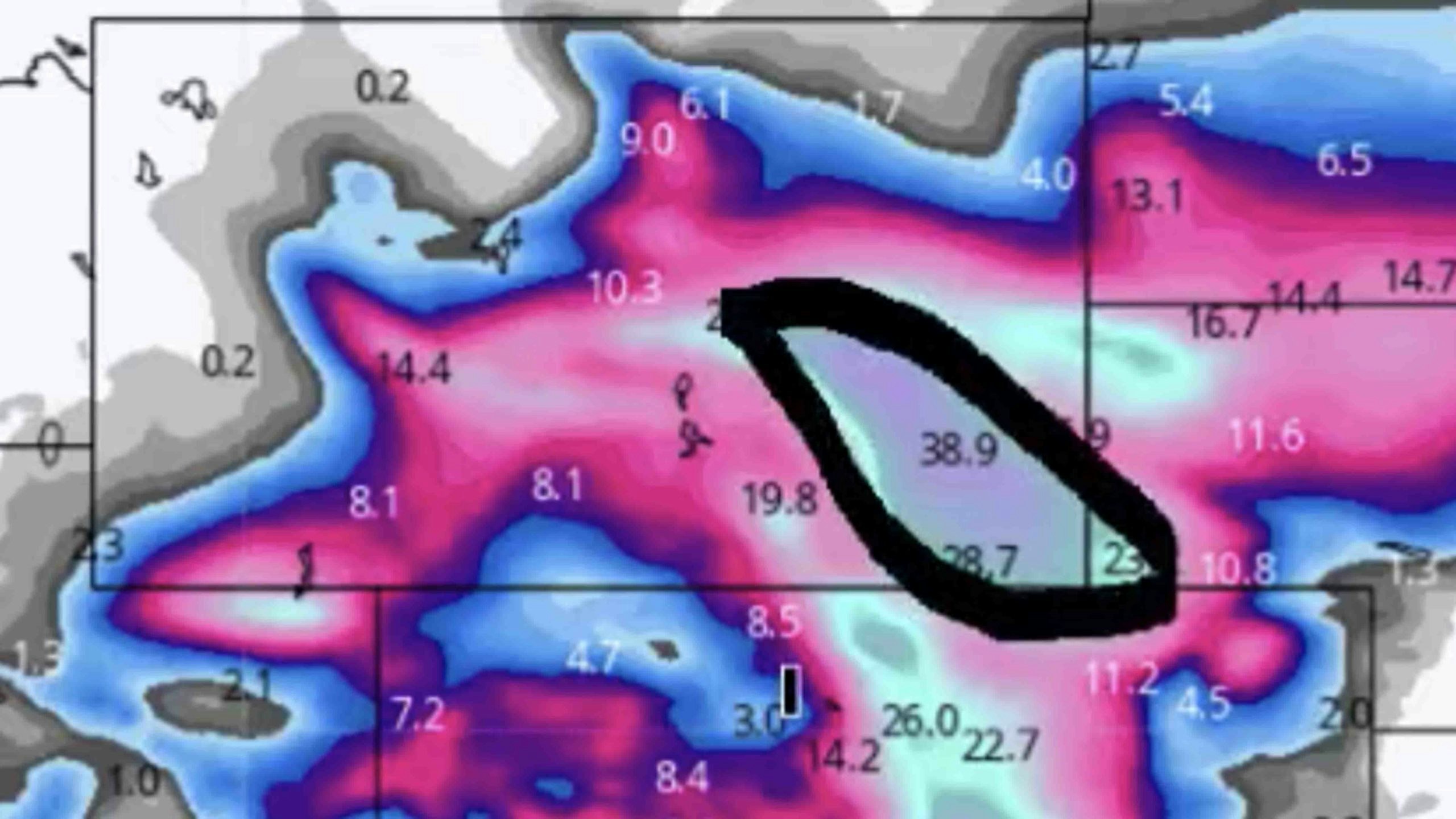
These are the latest updated snow forecast and precipitation totals I’m showing you the latest projection of total precipitation through early Monday and you can see there along the front range for South of Denver, up to Cheyenne up to Casper back to Lander, all of that orange, anything that’s orange is two inches or more, the darker red, you’re getting over three inches.
Again, this is a prediction. Notice there is less here and I’m going to show you here on the simulated stat satellite.
Why there’s a little wedge here of drier air, that’s going to lead to less precipitation amounts there, which is too bad. This is going to be great moisture. But I wish they would get a little bit more here.
But look at Nebraska. And look at East Central and southeastern Wyoming and the Front Range of Colorado, there’s going to be a tremendous amount of water available.
And when we convert that to snow, due to the fact that temperatures aren’t terribly cold, it’s going to be about a 10 to one ratio on the plains meaning one inch of water is going to mean about 10 inches of snow.
It’s going to start as a very wet snow then get drier as we go on. But all the areas in blue and pink and purple are where you’re going to see the snow accumulate the purple and the gray here in southeast and East Central Wyoming definitely showing the bull’s eye.
Really there’s two bullseyes and a lot of these are terrain induced due to the higher terrain getting lifted up along the slopes of the mountains and the foothills.
We had mentioned yesterday that there’s going to be a bit of a snow shadow west of the major mountain ranges.
There’ll be a bit of a snow shadow into Walden, a little bit of a snow shadow west of the Laramie range and snowy range mountains and the mountains – you see this hole right here in northwestern areas of Colorado where that mountain flow, that flow of air from the east is going to take away a lot of the moisture on the eastern side of the mountain.
So the western side of the mountains aren’t going to get as much nonetheless, there is so much moisture and energy going to get over the divide, you can still see there’s going to be precipitation getting into western Colorado, southwestern areas of Wyoming and even eastern Utah as well.
Wind is going to be a factor. These are the forecasted wind gusts with the storm and we have this area of really strong winds up here in Nebraska, southeastern areas of Wyoming in the northern Colorado.
You’re going to have sustained winds 20 to 30 gusting 40 to 50 miles an hour or more in this area, so that will cause blizzard conditions.
We’re also gonna have high winds blowing snow and blizzard conditions near South Pass and also in Sweetwater County and east central parts of Sweetwater and Carbon County.
This is going to be what’s called a gap wind, where the wind gets pushed through the mountain terrain and the gaps in the mountain ranges.
So we’re gonna have a lot of wind on I 80 right here with the snow as well. And then on the bottom side of that low, strong winds impacting New Mexico today, tonight and into early tomorrow.
So this storm folks has everything.
Here’s the simulated satellite photo, I showed you this yesterday. This is kind of fun.
This shows you what a satellite photo should look like by noon tomorrow. And as you can see, we have the long fetch moisture getting drawn into Wyoming and Colorado.
You see the curl, where the upper level low is going to be the counterclockwise spin around there.
And also notice and I talked about this earlier you see that dry wedge right here.
The storm is so strong, the counterclockwise circulation brings drier air into the storm out of Mexico and the desert southwest and brings it in.
So you’re gonna see a clearing out here in western Kansas, right here during the day tomorrow and into tomorrow night.
And what will happen is, this pocket of dry air will get pulled into the storm Sunday night into Monday effectively causing the storm to reach its peak and dissipate as it drifts off to the north and east it will not be nearly as strong.
So what happens and this is typical in these high plains Rocky Mountain big snowstorms is the storm actually goes through its whole lifecycle right on top of us.
And that’s where you tend to get these big, big snow events. As the storm develops, goes through its whole maturity process. It gets really strong and then it begins to dry out and dissipate as that dry wedge gets pulled in and very typical for that to happen.
So folks, there’s no turning back. Hopefully you can get through everything. Okay, thanks for listening and watching the day weather podcast. And we’ll see you on Monday. Might have a special update for you tomorrow morning. If we see any changes. Good luck with the storm and be prepared


