It’s going to be a roller coaster of extremes for Wyoming weather over the next few days.
Wyoming’s weatherman Don Day, in his daily podcast, said the state is going to be blasted by desert-heat over the next few days but then the jet stream “buckles,” bringing in cold air from Canada.
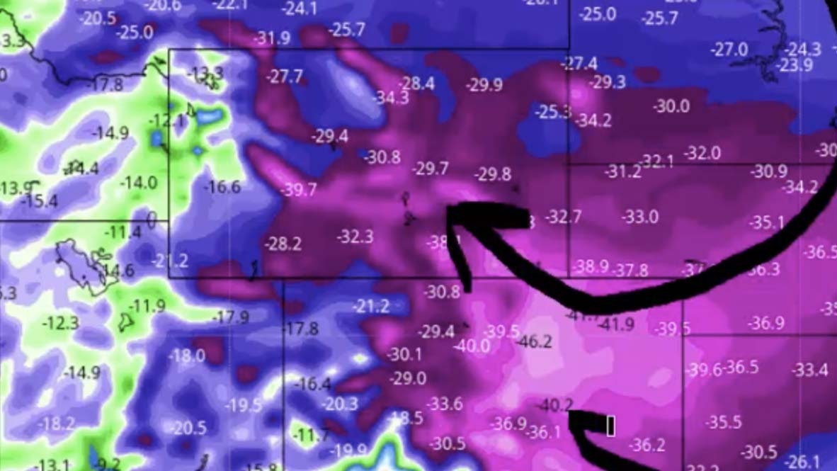
“Look at all this purple,” he said of the computer model showing the cold air. In some areas of Wyoming and Colorado the temperatures are 40 degrees below normal.”
Day said the computer model is likely overdoing things but there is a possibility for freezing temperatures and snow — even on the plains — happening next week.
“Look at that, over an inch of snow in Casper and maybe a lot of snow in the Wind Rivers, the Big Horns, the Beartooths, the Front Range mountains of Colorado and the southern Wyoming, and the Laramie Range,” he said while looking at the computer model.
The full rough transcript of his podcast is below. Or just watch the embedded video for more.
———
It’s Thursday, September 3, 2020. And here’s your Day Weather podcast.
Well, folks, it’s gonna be interesting here over the next week in terms of what we’re going to see.
First of all in the short-term, it’s going to get hot again, high pressure builds over and takes over strongly again across the Great Basin and Rockies.
However, it’s temporary because after a big warm up, basically through Sunday over the next four days it’s going to get hot again, then we’re gonna have a big cool-down coming next week. Much colder with rain and yes, folks, we could very well see a chance of snow even on the plains early in the week next week starting late Monday, Labor Day Monday into Tuesday and Wednesday and next week.
Temperatures are going to fall sharply by late Monday into next Tuesday and Wednesday, and we’ll show you why.
Here we are for the forecast for Saturday. Look at this big high on Saturday over the four corners region in the Great Basin. So basically for today, Friday, Saturday and Sunday, we’re going to have the heat from this desert high rebuild and expand across the Intermountain West in the western plains, with the … main jet stream riding far to our north.
But way back up here in the northern and Western Atlantic, there’s actually some tropical activity, some typhoon activity that’s going to get its energy into the jetstream and cause the jetstream to basically buckle and cause a big area of high pressure to build back up into the Gulf of Alaska.
And here we see it forming by Sunday afternoon into Monday. See the high building in the Gulf of Alaska connected to the Great Basin high right here. And notice the jetstream buckles and when that happens, you get that release of colder air from Canada.
So this is late Sunday into Monday morning. By the timeframe of Tuesday, we have a big high up in the Gulf of Alaska, the Pacific Northwest and it drives another wedge of colder air into the High Plains and Rockies. Now this is very similar to what happened early this week. However, this plunge of colder air is deeper.
There’s going to be more moisture with it. And a lot of the computer models are green on a trough and a strong cold front Monday night Tuesday and Wednesday across the High Plains and Rockies. Now this is both good news and bad news.
The good news is this could be the best chance of widespread precipitation in a long time in the drought-stricken areas of Wyoming, Colorado, Nebraska, parts of Montana and the Dakotas and into the plains states.
Yes, we are going to see a real big cooldown but it could be wet. Here’s the cool down. Look at all this purple. This is by Tuesday. In some areas of Wyoming and Colorado, temperatures are 40 degrees below normal.
Now that is likely overdone. However, the possibility of freezing temperatures and the first flakes of snow even on the plains could happen next week. If we don’t get cold enough for snow we’ll certainly see some good chances of rain and certainly the high country of Wyoming and Colorado is going to have a good chance of snow.
So for archery hunters headed to the field, next week, you probably are going to see a cold wet pattern up in the mountains for a few days. As we see here, zooming in, look at the close-up of these temperatures. Right here, this is by noon on Tuesday, Denver 46 degrees below average with our temperatures, that basically means temperatures in the upper 30s and lower 40s by noon on Tuesday.
We’ll see if it’s that cold. Models, a lot of timesm overdo things as we well know. But this extensive area purple shows you how impressive that cold air is. But when you get cold air like that this time of year, you’re going to get some upslope conditions that are going to form and hence there you have the good chances of precipitation.
Look at that, over an inch in Casper maybe. A lot of snow in the Wind Rivers, the Big Horns, the Beartooths, the Front Range mountains of Colorado and the southern Wyoming, the Laramie range, even up into the Pine Ridge of Nebraska, the Panhandle, Nebraska, that’s likely going to be rained.
And it’s a pattern folks to pay close attention to because we’re going to go back to hot summer weather here for the next four days. Then we’re going into reverse. And here we are with the forecasts of potential snowfall with this front. Now again, take this with a grain of salt but you can see even down into New Mexico.
We have got this large area by next Tuesday and Wednesday, we’re gonna be cold enough for snow reaching certainly the highest elevations and maybe those lower elevations above 6,000 feet. So it’s something to watch. We’ll update you tomorrow. So be ready for the heat. Then be ready for a 180 again next week. See you on Friday, have a good day.


