The following is a rushed transcript of Don Day’s Wyoming weather forecast. For best results, watch the above video.
Winter Storm will be moving thru and then improving weather is coming.
We will have periods of moderate to heavy snow for many areas of southern Wyoming.
Confidence is very high. We’ve seen this pattern dozens of times and it is one of those patterns that makes it snow and the confidence is high.
Temperatures will moderate some by Friday and then into the weekend. So there are some better days ahead.
It’s not going to get real warm but it’s going to get warmer than it is right now and more spring-like.
Heads up travelers and stockgrowers. Be prepared for the next 48 hours. We’ve got stressful livestock conditions coming. Be prepared for winter conditions thru early Friday.
Here is the updated precipitation forecast for Wyoming. You can see that it is a forecast that basically looks the same as I’ve shown you for the last several days.
The east/west trending area of heavier precipitation. We have that really strong jet stream wind that’s coming over and on top of a Canadian cold front that is going to back up against the mountains.
Then Pacific moisture is coming in from Washington and Oregon. So basically, we have three things. Good moisture, strong upper level jet stream winds, and a surge of Canadian air.
Also, we’ve got upslope winds coming underneath. This is one of the situations where the surface winds are coming in upslope from the northeast.
But the upper level jet stream winds are coming in from the west /northwest. So they are coming in from opposite directions and that adds lift to the atmosphere. That is one reason why we are so confident that what you see here will transpire.
You can see that the I-25 corridor — Wyoming into the front range of Colorado — is under the gun for significant snow. And then Interstate 80 from southwest Nebraska and southern Wyoming all the way to Evanston.
You can see the Sno-Chi-Minh trail — Rawlins to Laramie and then Laramie to Cheyenne is going to be hit pretty hard with significant snow. And since temperatures are so cold so the roads are going to be much worse with this storm when compared to the last one.
Snowfall totals. If we were to use a 10-1 ratio, it would look like this. You can see a lot areas are over six inches. You can see the pink. Over a foot of snow.
Because temperatures are going to be colder, this could be under-forecasted in the snow amounts.
If we use another snow forecasting tool called Cuchera, you can see that with the air colder, the snow amounts could be a little heavier.
You see in the southern mountains over 20 inches, that probably is going to take place.
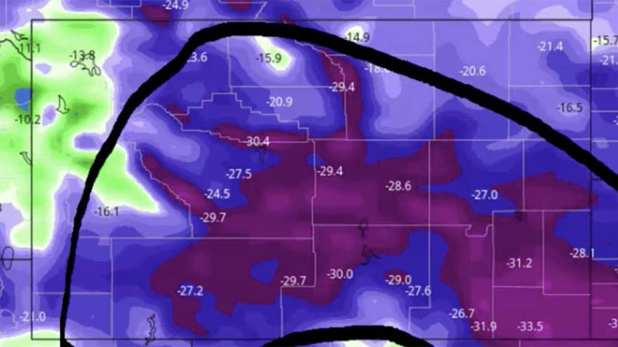
Be ready for the return of winter weather conditions. By tomorrow, these are our temperatures relative to normal.
You can see plagued by this big purple monster of unseasonably cold air banked up against the front range and the continental divide.
As we go forward, things look better.
Purple monster goes away and we get some orange and yellow on the map. We start to see near average temperatures return by the middle of next week.
So it’s not all bad news.
Just to give you an example of the jet stream pattern. We’ve mentioned this over the last week or so. This is something we would normally see in mid-winter.
There is a huge trough coming in the United States and it isn’t just us, everybody in this area here across Canada and the US is experiencing very cold April weather.
By Sunday, we still have a west coast ridge but it’s not going all the way up into Alaska and the flow of air into Wyoming is more from here. More from the coastal areas of Washington, Oregon, and northern California so that means the air will be more mild.
Going out further, by next Thursday the flow is more westerly. More directed toward central and southern California which means it will get more mild.
We showed you this yesterday, there is now a trough in the Gulf of Alaska instead of a ridge. That changes things. That means more mild Pacific air for us and less Canadian air being more directed this way.
We will see a modest warming trend this weekend through the middle of next week.


