Unsettled weather is going to be the rule. Scattered rain and snow and fog will be found across the lower elevations again today.
A stronger storm system is still poised to move in on Friday and early Saturday. But we have horrendous computer model agreement, I am afraid to say. Like last week’s storm.
Now better weather is coming in behind the system for Sunday and early next week.
Although I have to tell you that the models are in complete disarray once we get past next Wednesday.
So we aren’t going to talk too far into the future today. Hopefully we will have more clarity tomorrow.
Here is the upper level low coming in the California coast — this is by early Friday. You can see that we’ve got the storm system coming into the four corners area.
It is not closed off yet though We really like to see these four corners low get closed off right here about this time to become a big impactful storm for the front range of Wyoming and Colorado.
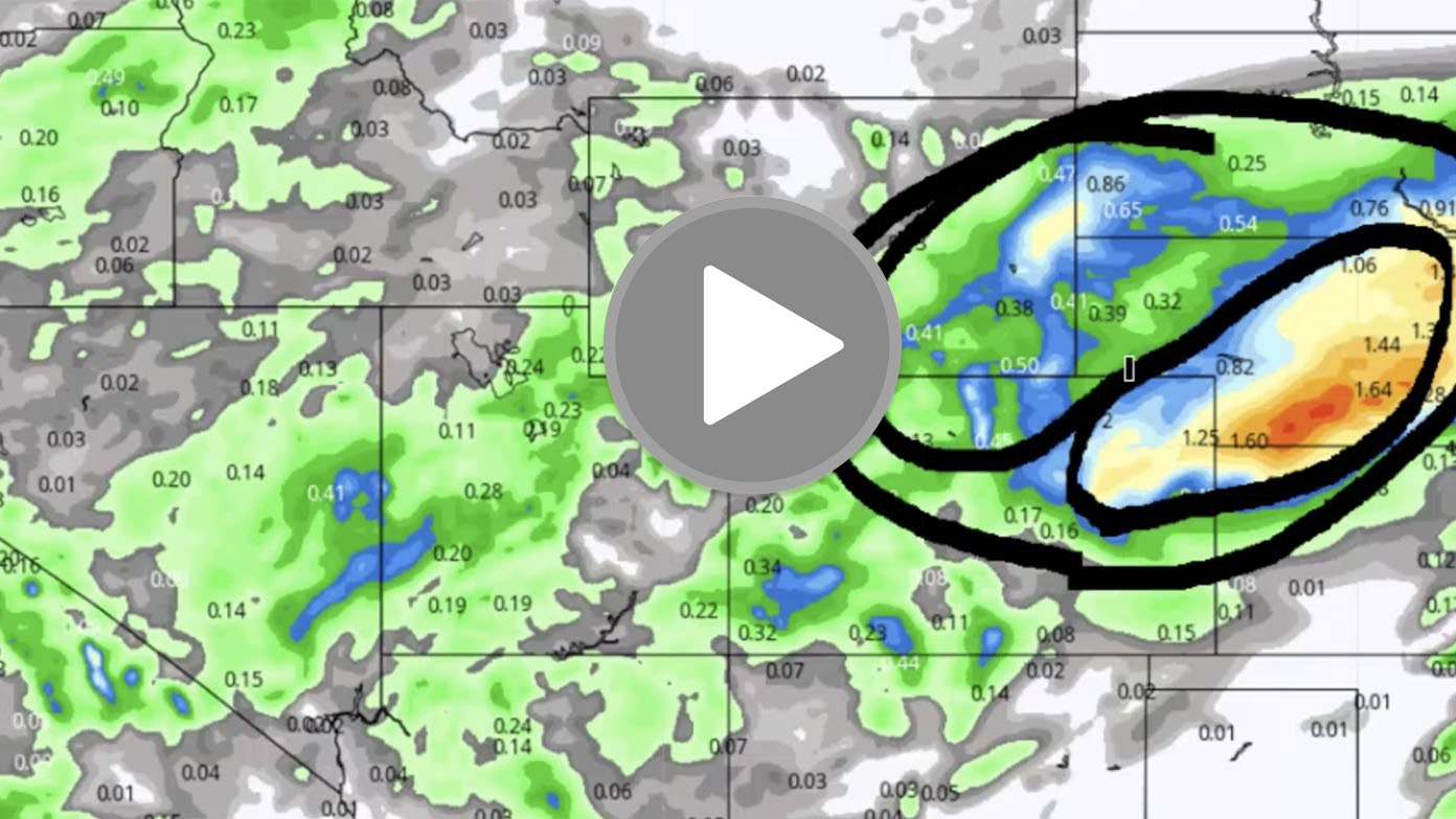
However, by Saturday morning, the system does get better organized. We have the closed low over northwest Kansas and this will bring some upslope into this area here during late Friday and into Saturday morning.
These are the areas affected the most. This is looking almost identical to the storm we had a week ago.
The heaviest precipitation in northeast Colorado and portions of Nebraska. That is where the heaviest moisture will fall.
On the backside of this system, more of a moderate event of rain and snow. But it is an impactful storm, nonetheless.
We are going to have some stout and strong northwest winds again on the backside of this system as it moves thru Friday night and Saturday.
So if you are traveling in this area, be prepared for wet to slick to slushy roads especially above 6,000 feet. Stockgrowers be ready for cold, wet, windy conditions in this area here which will affect young and weak livestock.
Snowfall totals look like this. Now, I do expect that there will be a high degree of variability in terms of who gets the heaviest snow and not.
But if we were to go with the higher terrain, especially above 5,000 and 6,000 feet is where the most snow is falling.
Out on the plains of Colorado and Kansas and Nebraska, stockgrowers need to watch out for wet, spring, wind-driven snow.
Again, this is almost identical to what happened a week ago.
The upper level low moves out into the Great Lakes area on Wednesday and Thursday.
And look at this: we’ve got an area of high pressure moving in.
So as we get into Sunday, Monday, Tuesday, and Wednesday, we are likely to have some good weather.
So we get a happy face. Better weather which a lot of folks would like to have. We have it early next week.
But up here we have another trough and by the second half of next week, these systems could be moving in.
However, they may also stay up here and stay up in Canada. There is a lot of disagreement.
One thing that we do see: we have a storm to deal with on Friday and early Saturday, then we have a break in the weather for Sunday through Tuesday and maybe lasting into Wednesday.
Thanks for listening and watching the Day Weather Podcast. Have a good day.