This is a rough transcript of Don Day’s video podcast for Wednesday, February 5, 2020.
There’s a lot going on weather-wise.
Today, the wind is going to be picking up across the region. It will cause a concern for travelers as blowing and drifting snow is already a problem along I-80 and I-25, especially I-80.
We are in between weather systems today so it’s going to be fairly quiet. We’ll still have to deal with the gusty winds across the state again.
We go into Thursday and Friday, we’ve got another winter storm to talk about.
We have a unique combination of very strong jet stream winds bringing in Pacific winds and moisture and cold air on the ground working together to bring snow to most of the state and region.
The jet stream’s trajectory is coming off of the Pacific off of southern British Columbia and is diving south right across Wyoming and Colorado going right over the Continental Divide.

This is bringing in copious amounts of Pacific moisture right into the heart of the Divide and what’s also impacting things is that we’ve gotten colder. We’ve got cold air packed up along the Divide.
The strong jet stream winds cause the atmosphere to lift. The atmosphere is lifted even more over the mountains that squeezes out the moisture. The cold air provides a little bit of upslope along the Divide.
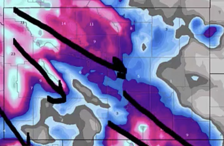
The pattern of northwest to southeast flowing jet stream winds produces a band of snow that goes right under it — it shadows it.
The snowfall forecast through Saturday morning — the snow is trending northwest to southeast across the area. That’s how the bands are setting up.
The pink and purple you see on the map over the mountain areas — this is going to produce a tremendous amount of snow in the Snowy Range and the Sierra Madres of Wyoming.

Also the Big Horns, the Wind Rivers, the Yellowstone Plateau, and the Jackson area.
The purple area here from Casper to Laramie to Cheyenne to Saratoga and Rawlins and all the way to Denver.
This is a bit of different animal compared to what we’ve had lately. This snow will fall late Thursday, Thursday night, and into Friday and Friday night.
But across the northern half of Wyoming — the Big Horn Basin along the I-90 corridor. It will start as early as tonight.
While the snow in this area will go into full force on Thursday afternoon and overnight Thursday into Friday morning.
There will be tons of headaches for travelers, livestock interests — be prepared for cold, wintry weather conditions again.
These snowbands will migrate east and west. They will wiggle a little bit. This is what the model thinks the heavier snow will be. But the band could end up further east or west.
Right now, this is a good representation of where we think the heavier snow will fall.
The snow will move out by Saturday morning. But another small system could produce snow again on some areas on Sunday and Sunday night.
The hits keep on coming folks. The 10 day forecast. We are highlighting temperatures relative to average.
It will be very warm in the eastern and southeastern United States. You’ll hear on the news how there’s no winter going on.

But look out west from the Dakotas to the Rockies even out to California. By next Friday, notice the severe cold that will continue. This not a little blip, this is a pattern that will be persistent that will go for the next week to 10 days.
We’ve got a lot of tough sledding to get through. If you are a snow lover, you’ll love this forecast for the next week to 10 days.


