UPDATE 7 p.m.: This story has been updated to reflect the most recent size and continment estimates for the fire.
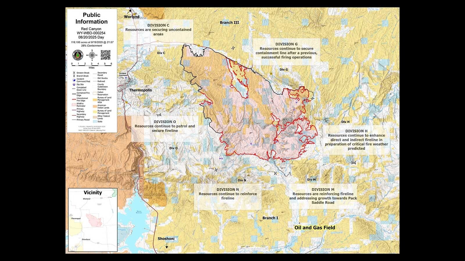
At nearly 127,000 acres and 31% contained, the Red Canyon Fire has been out of control and challenging to fight since it was ignited by lightning Aug. 13.
The next couple of days will be critical in trying to keep the wildfire burning about 11 miles east of Thermopolis in check as temperatures soar near triple digits and the fire makes its own erratic, dangerous weather.
“These next 36 hours or so are not going to be fun” for the 529 firefighters battling the blaze, said Cowboy State Daily meteorologist Don Day. “It’s typical August in the Bighorn Basin, which is traditionally a hot, dry place.”
That means temperatures in the mid-to-high 90s, possibly pushing triple digits, he said. Along with low humidity, the conditions are perfect for fueling wildfires.
“They make their own weather on a local scale,” Day said. “When the fire gets hot, then you match it with the heat of the day, you get thermals.”
Those can manifest as thin twisters that resemble dust devils, only they pick up the surrounding smoke, he said. Those can be dangerous for people on the ground and aerial assets attacking wildfires.
“You have this vertical motion of the air because it’s warmer. It’s the same process that’s going to cause a dust devil,” he said. “They pick up the smoke and other debris, and they’re exacerbated by fire.
“That makes it extremely unpredictable and extremely hazardous. It can be a nightmare and a beast.”
Pushing South
The Rocky Mountain Area Complex Incident Management Team 2 (RMCIMT2) in command of the fire reports progress despite the challenging weather and terrain.
At close to 120,000 acres, the fire’s total area is still growing, but at a much slower pace than several days ago when it exploded by tens of thousands of acres a day.
It also remains a reported 28% contained, mostly along the fire’s western and northern fronts.
By 6 a.m. Wednesday, firefighting crews on the ground were reporting some “outflow winds, which usually means it’s coming from a thunderstorm,” said the team’s public information specialist, who said she only goes by KT.
A thunderstorm is almost alive, she explained, in that it takes in air and expels it, so “outflow” winds are the latter.
The rugged terrain of the area, which is mostly grass and brush, also creates problems.
The most volatile area of the fire is on its southern border, the RMCIMT2 reports.
“Strong southeast winds drove challenging fire behavior on the south end where crews and aviation resources worked along Pack Saddle Road to prevent the fire from crossing,” according to the team’s Wednesday report.
‘These Fires Are Such SOBs’
Conditions for firefighters will improve by the weekend, Day said, but it will be rough until that happens.
“The biggest help is coming during the second half of the weekend into early next week,” he said. “It’s going to be cooler and — I’m not going to say there’s 100% chance of it raining on the fire — the general trend will be more favorable to (the weather) being more cooperative than getting worse.”
The winds will continue to be erratic, Day said.
“They’re going to get gusty winds in the afternoon, up to 20-23 mph, but not sustained high winds,” he said. “I expect the wind conditions are going to be most erratic in the afternoons … and could be troublesome.”
The combination of almost no humidity, hot temperatures and erratic winds are just what wildfires feed on, Day said.
“That’s why these fires are such SOBs at this time of year,” he said.
Evacuations
In the meantime, several areas in and around the Red Canyon Fire remain under evacuation orders, including:
• Buffalo Creek Road between Jones Creek Road and Reck Road, extending to the Fremont County line. This includes Kirby Creek, Lake Creek, Bridger Creek, and the Pack Saddle area.
• Kirby Creek Road between Red Hole Road and Buffalo Creek Road.
• In Fremont County, east of North Bridger to Nowood Road, and Nowood Road to the Natrona County line.
Other Fires
There are a few other large wildfires burning in Wyoming which, along with the Red Canyon Fire, prompted Gov. Mark Gordon to declare an emergency.
• The Spring Creek Fire burning about 10 miles southeast of Ten Sleep has burned about 3,600 acres and is 30% contained, the National Interagency Fire Center reports.
• The Sleeper Ranch Fire northeast of Meeteetse has burned about 20,000 acres and is 90% contained, the NIFC reports.
• The Bull Lake Fire has burned 525 acres in the Bridger-Teton National Forestr and is 30% contained, according to the NIFC.
Contact Greg Johnson at greg@cowboystatedaily.com
Greg Johnson can be reached at greg@cowboystatedaily.com.