As one of Wyoming’s patented winter windstorms performed an encore Monday after a weekend of blowing trucks over on state highways, nobody was safe from the 80 mph gusts.
Not even the weatherman.
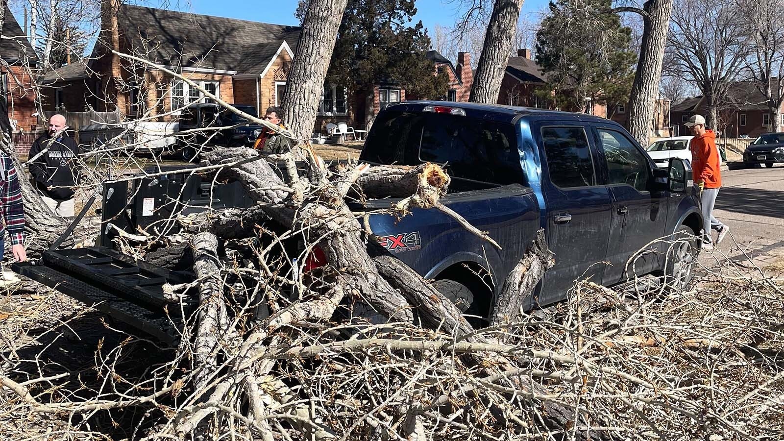
On Saturday, which saw the worst of the weekend wind, Cowboy State Daily meteorologist Don Day went outside his Cheyenne home to find a giant 100-year-old cottonwood had dropped a huge branch on his truck.
Most would call that bad luck, while others say that for a weatherman, it may be a bit of poetic justice.
“I shouldn't call it a branch,” Day said. “It was half a tree, really.”
Day hasn’t had a chance to get the damage assessed, but there’s no mechanical damage as far as he knows. He’s able to drive it, at least.
Day has consistently downplayed the intensity of the 2023-2024 winter season, assessing it as erratic but not so unusual. Despite its best efforts, the damage caused by the cottonwood tree has not influenced his opinion.
And the irony of the tree hitting his truck isn’t lost on Day, saying that “it's about time the weatherman took it on the chin.”
Strong, But Not That Strong
On Saturday, when Day’s truck branched out, Cheyenne's top recorded wind speed was 66 mph. The strongest wind gust in the state that day, recorded by the National Weather Service Office in Cheyenne, was 84 mph in Bordeaux, 60 miles north of the capital city.
Laramie was blown over by 55 mph, 73 mph winds roared through Vedauwoo, and the infamous Interstate 80 corridor near Elk Mountain recorded winds of 65 mph. High Wind Warnings remainder in effect for most of southeast Wyoming on Monday, as well as the Bighorn and Wind River Mountains.
Day doesn’t deny that the windstorms of the weekend were powerful. However, he sees it as an outlying event for this winter season, and an unremarkable one, at that.
“I haven't added up how many high wind warnings there have been so far this winter, but I can tell you anecdotally that we haven't had nearly as many as we had the past few winters,” he said. “We haven't had a lot of high wind events, but I would say that what we’ve had was nothing extraordinary.”
Geographically, Wyoming’s already a natural wind tunnel. Wyomingites are accustomed to buffeting strong winds, regardless of the season.
That’s why Day isn’t adding more wind to the sails. During a season when high wind events are usually more frequent, he doesn’t see the strong wind gusts recorded over the weekend as anything out of the ordinary.
“To have 60-70 mph wind gusts during the winter during these events is typical,” he said.
A Story Of Fire And Ice
Day wasn’t the only one vehicularly impaired Saturday. A fast-moving wildfire near Cheyenne temporarily closed I-25 while several agencies battled the 6-foot-high flames.
Strong winds helped the fire spread quickly, while many people lamented that persistent dry conditions were making it worse. Day doesn’t share that outlook since it hasn’t been all that dry in southwest Wyoming this year.
“Cheyenne’s had several snow events and above-average precipitation in February,” he said. “Prairie grasses are still dormant, so the grass that’s out there is dead from the winter. So, you have a situation where you got dead grass that doesn't have snow cover, then you have high winds, and then you have an ignition source, which is a person or machinery, you're going to have grass fires.”
The source of Saturday’s fire hasn’t been determined, but the most likely explanation is a person or machinery. Lightning can be ruled out, given that it was windy but mostly sunny around Cheyenne that day.
Even the lack of snow cover on the Wyoming plains isn’t necessarily an indication of disquieting dryness. Day said that has always been another consequence of strong winds.
“When you get east of the mountains in this part of the country, we're in what we're calling a chinook zone, down-sloping westerly winds that warm up the air,” he said. “Snow cover doesn't last long here because those chinook winds can eat up that snow.”
Day noted that the derivation of the American Indian word “chinook” means “snow eater.”
‘What Have You Done For Me Lately?’
It’s been an erratic winter season in Wyoming, which is why Day officially christened it “whiplash winter.” The weekend’s windstorms were another flogging from the whiplash winter, and more lashes are coming.
High Wind Warnings, in effect until 8 p.m. Monday, are being traded for Winter Storm Warnings, mainly in the mountains of western Wyoming. But while there might not be an official NWS warning for wind (yet), Day anticipates a lot of bluster Tuesday.
“Most areas of the state are going to be getting some snow tonight and tomorrow,” Day said. “But there is going to be a lot of wind with that front as it comes through.”
According to the NWS offices in Cheyenne and Riverton, higher elevations in Teton and Park counties and Yellowstone National Park could see between 12 to 18 inches between Monday night and Tuesday, with between 4 and 6 inches expected at lower elevations.
Meanwhile, there will be a noticeable drop in temperatures throughout the Cowboy State.
In Cody, the high of 55 on Monday will be followed by a high of 21 on Tuesday, with an overnight low in the single digits. Casper will get the whiplash of daytime highs of 53 to 23 from Monday to Tuesday.
Johnson and Natrona County residents could wake up to 4 inches of snow Tuesday morning. Lusk and eastern Wyoming might see an inch of snow, but their Monday daytime high of 58 will be sobered by a daytime high of 21 on Tuesday.
Buffalo will get the worst of the whiplash this time. Daytime highs are expected to plummet from 55 on Monday to 15 on Tuesday, along with up to 5 inches of snow.
Day anticipates it’ll get colder and snowier across Wyoming on Tuesday. And if he’s not being “in your face” about it, the wind probably will be on Tuesday, Wednesday and possibly beyond.
“I don't want to give the impression that the wind is going to stop,” he said. “It will not be as strong by Thursday and Friday, but it's still going be pretty stout through Wednesday.”
Day understands why Wyomingite could be perturbed, but it’s just a backlash of the whiplash.
“With people and weather it’s, ‘What have you done for me lately?’ So, what have we done for me lately?” Day said. “Windy and really warm. But two weeks ago, many places had snow and it was a lot colder. That was only two weeks ago.”
As for what lies ahead, there could be a lot more whiplash this winter. But as Wyoming enters its wet season, it should be like a splash of fresh water to the face.
Knowing Wyoming, the end of winter and the beginning of spring could feel like an aggressive splash. Day doesn’t predict weather that far ahead, but believes Wyomingites should brace for splash and whiplash in the coming weeks.
That’s coming from the Wyoming weatherman with half a cottonwood splintered across the back of his pickup.
“This is very much a roller coaster winter so far,” he said. “Winter will go out with a fight, so there's plenty more winter weather to come.”
Andrew Rossi can be reached at arossi@cowboystatedaily.com.


