Anyone who has traveled between the Bighorn Basin and the southern part of Wyoming knows that getting from Points A to B requires a drive through the Wind River Canyon.
Cutting through the Owl Creek Mountains, the Wind River has carved a breathtaking passage that was the obvious choice for engineers when creating the state’s highway system more than 100 years ago.
Geography also dictates that the canyon is the only shortcut between the north and south parts of the central part of Wyoming. And if the highway through the Wind River Canyon is closed for any reason, people traveling for commerce, tourism or health care reasons are out of luck.
“To get into the Bighorn Basin from the south, or to leave the Bighorn Basin and drive south, you have to depend on a canyon that has its own weather,” said Cody Beers, spokesperson for the Wyoming Department of Transportation.
A longtime Riverton resident who grew up in Cody, Beers is uniquely qualified to speak about the perils – and perks – of driving and recreating in the Wind River Canyon.
“It’s probably one of the most beautiful drives in Wyoming, easily,” Beers told Cowboy State Daily. “I would say it’s probably a top 10 Wyoming drive.”

Owl Creek Passage
Wind River Canyon is 14 miles long, less than 2 miles wide and nearly 2,400 feet deep in places. Boysen Dam lies at the south end of the canyon, and at the north end, the Wind River ends and the Bighorn River begins – although both routes feed the water that runs out of Boysen Dam.
Drivers on U.S. Highway 20/Wyoming Highway 789 may notice that at times, the highway is level with the canyon floor, allowing close-up views of the river. At other times, the water even appears to run uphill because of the unique geography and layout of the highway.
The passage is a geologist’s dream, cutting through rocks from the Precambrian and Paleozoic eras, ranging in age from several billion to 235 million years.
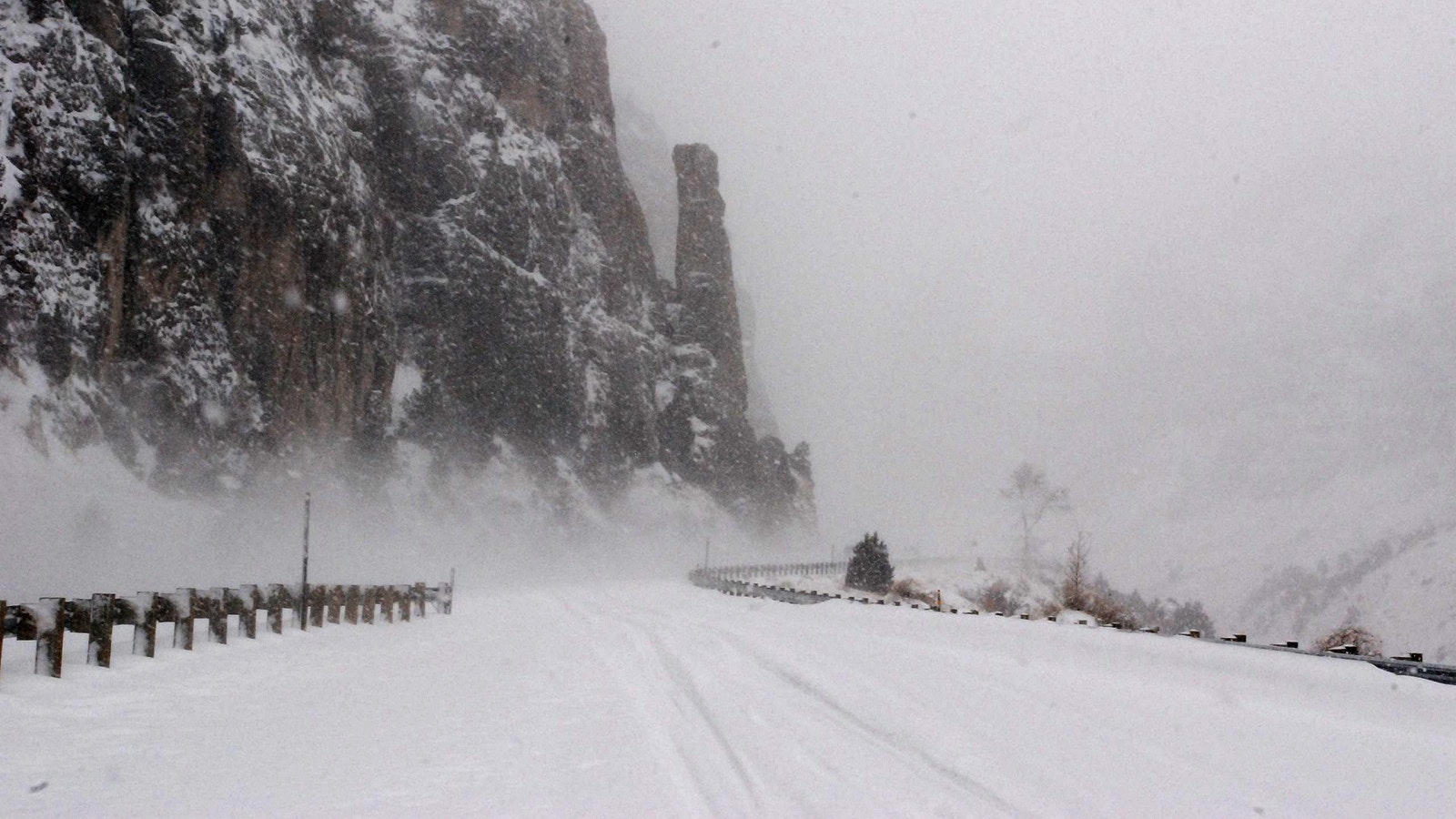
But the hazards that came about from the construction of the highway through the canyon are many – rockfall, snowy conditions and little room to pass make for a dangerous drive.
“I don’t think that when people built the road through Wind River Canyon more than 100 years ago they even thought about any of those things,” Beers said. “Because they were just trying to provide an easier way to get through the Owl Creek mountains.”

No Easy Way Around
If the Wind River Canyon closes – which happens infrequently, but enough to hamper travel a few times each winter – there are no easy alternate routes.
What normally takes 35 minutes to drive (in good weather), would take nearly 9 times as long — 5 hours and 15 minutes — if travelers have to re-route around a closed canyon.
“They can drive from Worland to Ten Sleep and over Highway 16 to Buffalo to get south,” he said. “And when we had the mudslides in Wind River canyon in 2015, people were having to drive through the east gate through Yellowstone, because we were shut down for about a week.”
A lot of people depend on that roadway for commerce and tourism, Beers said.
“It’s really the lifeline for a town like Thermopolis,” he said. “When that road is closed, Thermopolis might as well close their doors.”
And Fremont County might run out of soda, Beers added.
“When that canyon closes down, the one company that calls me every time is Admiral Beverage (in Worland),” he said. “They provide Pepsi and Mountain Dew to every business in Fremont County, plus every other Pepsi product.
“And when (the canyon) closes, it takes literally about a day for the shelves in stores in Fremont County to be void of soda pop.”
Rockslides and Other Hazards
Rockslides also can be a menace in the Wind River Canyon.
Beers recalled that the Memorial Day mudslides in 2015 came about because the region received around 4 inches of rain in a 12-hour period.
But the problems in the canyon are completely man-made, he said.
“There were no problems with that canyon before humans showed up,” he said. “We created the issue – we cut away the hillsides and created the rock sides.”
The loose rock created by cutting into the side of the mountains can break away when the ground gets wet or when temperatures vary in the spring and fall.
“It will warm up in the 40s during the day, and then it’ll drop to 10 at night, and so the ground is constantly expanding and contracting,” Beers said. “It creates its own type of rock slides because there’s that movement of the earth.”
Vehicle crashes are another man-made hazard that cause closures in the canyon – tragic events that in most instances are completely preventable, Beers said.
“We have entirely too many people getting in crashes in there,” he said. “It’s dangerous, but people are in such a hurry these days, and they just feel the need to pass because they want to drive as fast as they can humanly drive.”

Multi-Jurisdictional
Preservation and upkeep in the Wind River Canyon doesn’t fall just on the Wyoming Department of Transportation. The Burlington Northern Santa Fe (BNSF) Railroad maintains the rail lines on the west side of the river, and the state of Wyoming is responsible for managing land on each end.
Additionally, most of the canyon falls within the borders of the Wind River Indian Reservation, and sheriff’s departments in both Fremont and Hot Springs Counties are responsible for law enforcement in portions of the canyon.
“We plow the snow — WYDOT, that is,” Beers said. “We take care of the guardrail, we’ve put up retaining walls to hold the highway in place. There’s just been a whole heck of a lot of effort, almost every day, year-round, to keep that as a major transportation corridor.”

Potential Bypass?
Beers said there is a conversation happening about an option that would ease the pressure when the highway through the canyon is closed.
“Right now it’s just basically in the talking stage, about how to create a redundant route from Bighorn basin to the south of the canyon,” Beers said.
The potential bypass would take traffic from Moneta, on Highway 20/26, straight north over the mountains to Ten Sleep.
“There’s a decent road, if it’s dry, that goes over the mountain and hits Ten Sleep that way,” Beers said. “A lot of people drive it … some people make the mistake of driving it in the winter.”
He said during spring and fall storms, the undeveloped road is “iffy,” because the roadbed is partially formed from bentonite.
“When it gets wet it’s sticky and slimy and can bury any type of vehicle,” said Beers. “We’ve had cars get buried up there, and we’ve had semitrucks get buried up there.
“And then it becomes a search and rescue mission because that road really can’t handle vehicles year-round.”
Beers said WYDOT is just one rockslide away from having to make decisions about any sort of alternate route.
“I mean, if part of that canyon wall fell down, it might take us a month to clean it up,” he said. “So what do we do then?”
A Special Place
Beers said that keeping the highway through the canyon open is in everyone’s best interest – not just economically, but for the sheer joy of being there.
“I drive north when the weather’s good, at least once a week, and the best part of my drive is driving through that canyon,” said Beers. “I’ve been driving through that canyon since I was a little kid, either in the backseat of mom and dad’s car, or driving myself.
“I’ve had picnics in there, family gatherings, hikes – I’ve even secretly visited a couple of caves in there.”
“If people would just slow down in that canyon, they would be amazed at how alive it is,” he said.