The following is a rough transcript of Don Day’s Wyoming weather forecast for Monday, January 18, 2021.
Welcome to Monday, January 18 2021. Thanks for tuning into the day weather podcast. Well to start the week we’re going to have a system and to end the week we’re going to have a storm system. But in the middle, well not much going on.
So it’s like a sandwich with no meat in the middle. We got bread on top today, bread on the bottom by the weekend, but very little meat in the middle. But the pattern is getting more active.
Arctic air is still not able to move in yet. This is typical in a La Nina pattern for arctic air to have a hard time getting pushed south, even though there are a lot of large scale hemispheric suggestions that it will come in.
But the model still doesn’t see it quite yet. Although it will be trending colder by the weekend.
This is the strongest lining and going back to 2010 to 2012. So it’s something that is definitely dominated pattern. I know you’re probably tired of me talking about La Nina but to use a sports analogy, it’s flooding the zone.
It is completely dominating the pattern for the western United States and parts of the central US and the far west. It’s just completely taken over.
And the pattern that we’ve seen so far this winter is definitely a classic La Nina, speaking of La Nina here are the sea surface temperatures.
As we look, we see all the blue and the subtropical Pacific. Also notice the Northern Pacific is starting to get colder as well. And I’ll show you the sea surface changed since November. And some really interesting things are showing up.
We’ve got this warm pocket down here. But that’s not going to really influence our weather. It’s all about this area really right here. And also what’s developing up here, that will continue to impact our weather here for the rest of the winter season.
If you were to measure the heat content of the upper ocean, in the key area of the subtropical Pacific at that longitude, you can see that since April, that’s when things started to turn dry.
Last April, May in June is when the western states started to dry out. And we saw that the sea surface temperatures which they normally do warm up a little bit right at the peak of summer.
But look at the heat content of the subtropical Pacific since then, and it’s very, very low. So we’re putting very little heat into the atmosphere compared to normal, also less water vapor into the atmosphere because of the La Nina.
If you were to look at how sea surface temperatures have changed since November 13. Now notice there’s actually been a slight warm up in the subtropical Pacific since November. But they’re still as we just showed you in the map. They’re still colder than normal.
But look at this. Look at the North Pacific and then along the California coast, the sea surface temperature since November have dived. And this is something that we saw in 2011 and 2012.
That’s why we’re so concerned, getting more and more concerned about the dryness continuing this summer in the western United States, because this is exactly what happened with that strong La Nina about, about 10 – 11 years ago.
And again, I’ll say this, again, these La Ninas that are bad tend to be at the bottoms of solar minimums, which is what we just got through. So again, there’s no surprise on what’s happening.
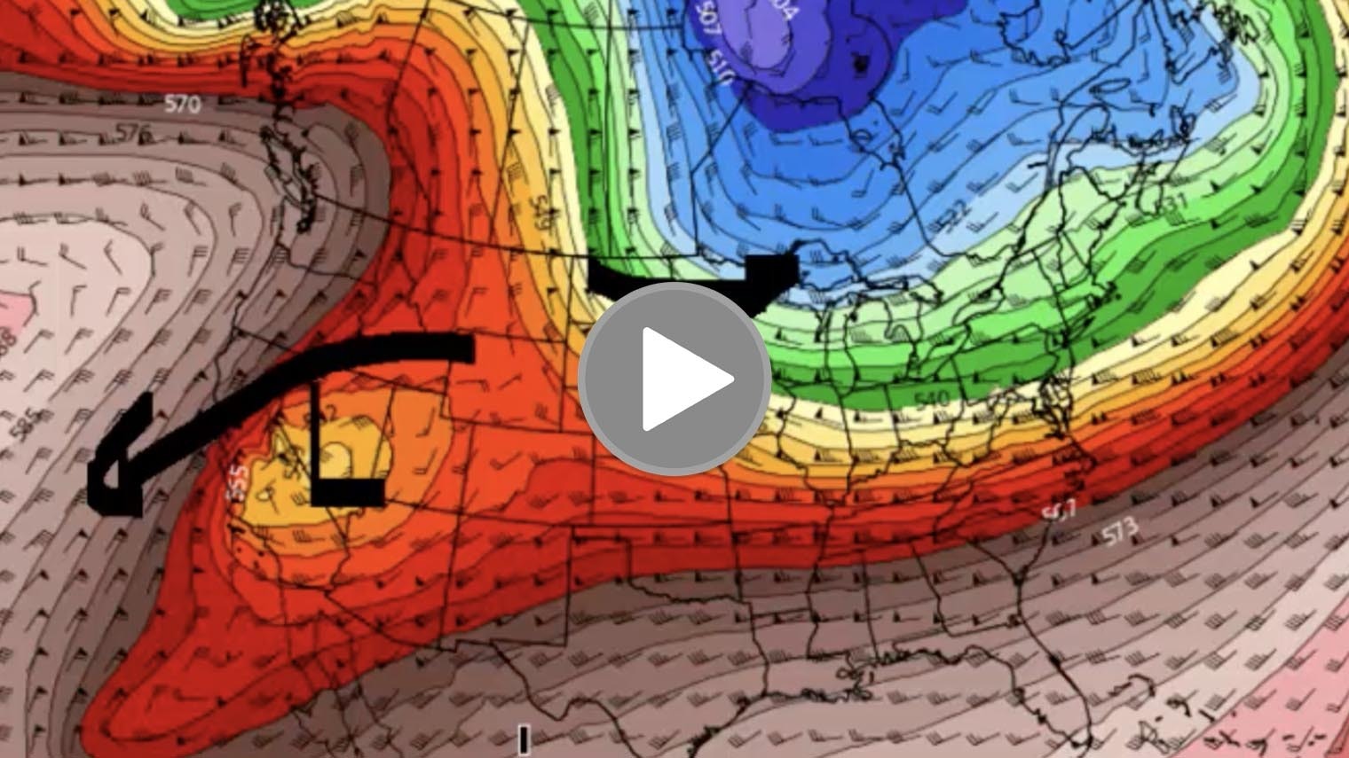
Now let’s take a look at how the weather pattern evolves in the short term. This is where we are today. We’ve got this broad trough coming in right here.
It’s not really well organized. But we did see some nice snow in the mountains of Wyoming and Colorado and parts of Montana, Idaho last night, and we’ll see some more up in the high country and a few snow showers in the plains.
But look what happens with this broad area of low pressure. It splits with a piece headed to the northern plains and this piece dropping Southwest into southern California.
This is again, something that happens a lot in La Nina seasons because the Jetstream winds are so strong. Then as we go further out, this is Wednesday, we end up with a low off the coast of Southern California.
Now this is bad news for California. Now I know that we don’t have many podcast watchers in California right now, but you’ll probably be hearing about this on the news.
So we’re giving you a heads up when you get a low that drifts off the California coast like this in winter, you tend to have a big surface gradient of high pressure in Utah and low pressure there so the air moves this way.
This is a classic Santa Ana. So what will happen is all of a sudden you get really worried really fast about the fire danger in California.
If somebody gets a fire started in the Santa Ana. Well, it’s bad news is you get these strong easterly winds.
And you can see it Southern California poised to have 50 – 60 mile per hour wind gusts or more with the Santa Ana developing this week.
Now as we get into the weekend, that low off the west coast gets pulled in. We have another trough coming on in and we see a general broad area of low pressure for this weekend, and that’s going to lead to better chances of snow and colder weather in the Intermountain West.
Now whether or not it’s a big organized storm well put together we’ll just have to see and we’re also going to be seeing small weather disturbances coming off the Pacific, Thursday night and Friday, bringing the mountains some snow here and a few snow showers to the plains.
So we’ll keep an eye on the weekend. The weekend could produce more in the way of snowfall and if we were to look through Saturday afternoon, you can see at least the computer modeling is showing an enhanced chance of snow coming back into the northern and central Rockies along with some colder temperatures for the weekend and into early next week.
Thanks for listening to watching the day weather podcast. Have a great Monday. Talk to you tomorrow.


