This is the Don Day Wyoming weather forecast for Wednesday, December 30, 2020
Below is a rushed transcription of Don Day’s forecast. Excuse the errors.
How is the year going to end? And how’s the New Year gonna start? Well, really not bad. It’s gonna be windy and occasionally chilly.
We’re gonna have some wind today, and into Thursday, we’ll have some wind again over the weekend.
But really, there’s nothing terribly bad coming our way other than the wind and chilly temperatures, but at the same time, we still don’t have any bitter arctic air to come on in.
We’re gonna have a few fast moving systems mainly impacting the mountains, we will see some wintry weather that is going to be heading into the central part of the United States this weekend.
But in this part of the region, we really don’t have much going on. So it’s gonna be a nice New Year’s Day. It’ll be nice about New Year’s Day was that most of you won’t have much wind by our standards. And it will be a fair dry day.
No major problems coming for travelers this weekend other than those windy areas. Now busy weather coast to coast. Starting next week, we’re going to spend some time today taking a look at the long range.
So there’s not much going on in the short term, we’ll take a look at the long range weather, taking a peek into 2021. Here we are with today’s weather, we’ve got the low that came in and brought the snow it’s headed to the Midwest, we have a piece of that low that’s left here.
There’s gonna be some problems here. We’ll share that minute there’s gonna be some problems here as well for travelers. But out here we’re looking at the weather improving, you’ll see this Well, this is a pretty impressive little low coming into the West Coast right here in the Pacific Northwest.
But it’s gonna break into two a part of the storm ago here, the other part of the storm go here, it’s gonna split. And since it splits and you can see it splitting. Here’s what’s left of it. And here’s the other part of it.
This is by Thursday afternoon. So here we are today. And then look what happens to the pattern just today later that storm split so there’s really not much left. There will be some snow in the higher terrain here as it goes through but it’s a weakening low.
We’ll keep it I guy on this guy later and this guy later on but what will happen is that this guy will head off to the east. And we’ll go to a more West East more mild flow this weekend. Snowfall wise This is through Saturday.
I want to show you that through Saturday, you can see that the mountains will see a little bit of light snow, we just see most of the heavier snow staying up into the Pacific Northwest mountains.
That’s because the storm splits but as the storm splits and we get a low down here, look what happens. We’ll show you here on a big map. Look at this. Holloway down into Mexico look at down into Texas, then into the Great Lakes and upper Midwest.
This long swath of winter weather cuts across many interstates and roads and highways. It’s not a wide band of ice and snow. But it’s pretty impressive Big Bend country could be looking at a significant winter storm as we head into the new year.
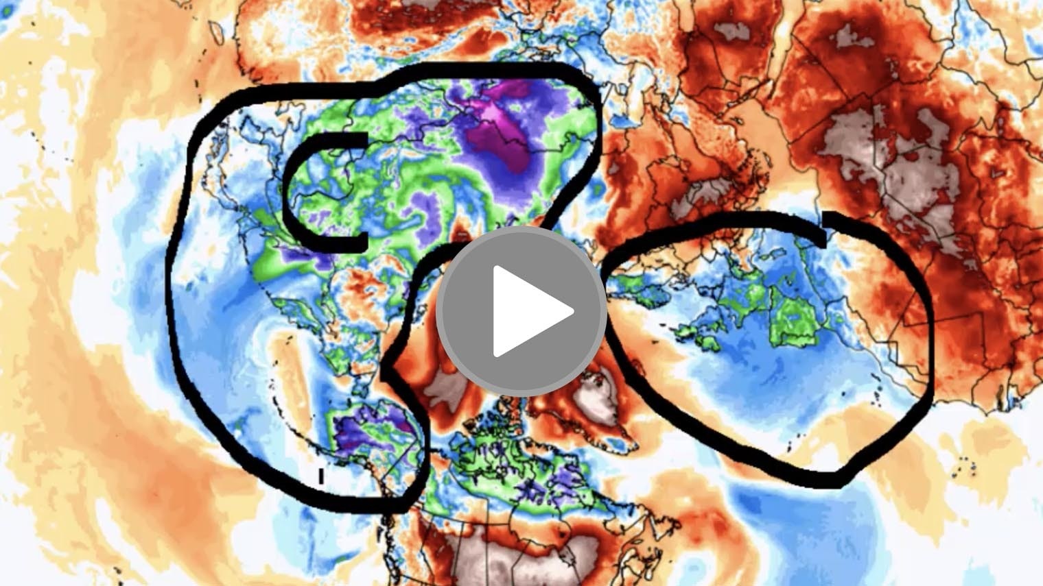
But for Colorado for Wyoming for Utah, the this this region here there’s just not much happening other than mountain snow showers and flurries. Now where is all the cold air. This is a map of the globe looking from space down to the north pole here.
We’re looking at the globe. Now this is Sunday. If you want to know where the really cold air is, it’s in Europe here.
And then we talked about this yesterday, and how we saw a lot of cold air in Siberia and into the Korean Peninsula up here across the North Atlantic. This is really the big cold air mass that we need to keep an eye on.
This is generating very strong Jetstream winds across the North Pacific. We’ll show you that here in a minute. But you can see the lower 48 and a good part of Canada pretty mild. As we go into the new year with above average temperatures really coast to coast.
But here’s that swath of wintry weather right here that’ll be taking place. Now as we go further out. I want to show you what happens 15 days out or two weeks from now. Notice that the cold in Siberia here and the warmth in the North America here in two weeks.
Look what happens. Now this is a computer model. But we could definitely see the cold still up in Siberia. But there’s a release of that cold into the lower 48 states, two weeks out from now. And so it’s still on the table.
It’s a long range model. So take it with a grain of salt. But if you’re wondering where the really really cold air is it’s locked up up there and right now, it has no way to come South but it could come south as we get into the first couple of weeks January.
Now going forward. This is what the maps look like for Saturday. We have a little wave coming through here. Here’s that Midwestern storm we just showed you.
That’s going to be moving out. More of a mild Pacific flow of air comes in this weekend. So temperatures will moderate a little bit. by Tuesday.
We have a cold front coming through this will bring the mountain snow a few snow showers in the plains but Again, with the Jetstream.
So fast across North America, you’re just not going to get any Arctic gear that can come south, at least into the starting next week. But look what happens when we go further out. This is by next Friday.
Look what happens. We have a big low here, good low in southeast Colorado, another low approaching the California coast, see how they’re lined up.
What’s happening is, is that and this is something that we’ll show you here in a little bit more in a minute. What happens in this pattern is you get a strong Jetstream that undercuts an area of high pressure. We talked about that blocking Ridge yesterday in the North Atlantic.
Well, it retrogrades to the west, and goes over in near the green south of Greenland Hudson Bay Area, as we get into mid to late next week. And what that does, is it takes the Jetstream and it pushes it further south.
That’s good news for California to get more wet. But what you tend to have is basically a train of storms that go coast to coast.
This is why we think mid late next week. And the week after that you’re going to hear more on the news about winter weather across the United States, because these specific storms instead of being directed up here will be directed more this way.
So January, is looking pretty interesting coast to coast, in terms of the weather getting more stormy. Now we’re going to go back and we’re going to talk about Arctic constellations, again, all the way through January 14 was where that map I just showed you was around, notice the Arctic oscillation remains in a negative phase, which is a cold phase.
Now I’m going to show you a new oscillation. It’s called the North Atlantic oscillation. We don’t normally show this to you because well, it’s the Atlantic, it’s far downstream from us. But in the winter, we do pay attention to it.
Notice, the North Atlantic oscillation is also in a negative phase, all the way through the next two weeks through January 14.
Now, what’s interesting historically, is when you take the North Atlantic oscillation, and you take the Arctic oscillation, and you put them together, if they are both in a negative phase, which they are, you tend to get patterns like this.
This is where you are, you get that colder air that is able to dive in North America, and you get the storm track that is more suppressed to the south.
And there’s that blocking high we talked about over Greenland. So what ends up happening is you get cold stormy weather in Siberia, in Europe, you had cold and stormy weather in North America, and very little going on in the Atlantic, the blue areas here show where the cold air tends to reside.
And that’s kind of where it’s residing right now, but does have an opportunity to come in. So when you take an Arctic isolation, that’s negative North Atlantic oscillation that’s negative. Those are cold phases for North America.
And you get a pattern that looks like this. That’s why right after the new year, for at least a couple of weeks, the weather across the northern hemisphere across North America is going to get more wintry.
I want to show you this is the upper level jet stream wind for Friday morning. Now, this is a little bit of a busy map I know.
But here’s the Aleutians. And here’s Alaska. So here’s Alaska right here, we’ll mark that with an A. Then over here we have Japan, we’ll do that with a J. Then here’s the West Coast, there’s the Pacific Northwest.
So now that you have your bearings, what I want to show you is is that that really bitter cold air that’s up here contrasts with the warmer Pacific waters here, that’s a little bit further north of those tropical areas.
Notice the Jetstream winds, these are winds at 30,000 feet, when you get a jet stream like this rocketing across the North Pacific in the winter. This is like fuel. This is like gasoline.
So what will tend to happen is this very straight wind, look how straight west to east it is. And it’s moving.
I mean, these are Jetstream winds that are 170 180 190 miles an hour. Least are forecasted to be like that. This is where you get clear air turbulence.
This is where you hear about flights going across the Pacific where they hit lots of turbulence. This is what happens in these situations.
Now what will tend to happen is, all of this stored up energy in the jet stream, eventually will not become a straight line anymore, but it will buckle causing a ridge and a trough.
And that’s where we ended up with this pattern here where you start to get more waves, more storms in the system.
So while we don’t have a lot to talk about in the short term, there’s a lot on the table in the long term. Have yourself a great Wednesday. We’ll see


