This is the Don Day Wyoming weather forecast for Monday, December 28, 2020.
Below is a rushed transcription of Don Day’s forecast. Excuse the errors.
It’s Monday, December 28 2020. Hope everyone had a great Christmas. As we start off this week, well, we actually have some winter weather to talk about.
We certainly got into some winter weather in some areas after Christmas day after a beautiful Christmas Day, a couple of fronts came through bringing the mountains and snow and we did see some snow showers in the plains in some areas of the region yesterday, but now a more potent winter storm is gonna be taking place.
It’s going to be coming up out of Central and Southern California, that’s a spot we haven’t seen a storm ticket track for a while.
In fact, there were parts of southern California that got an inch of rain last night good for them. Now, when you see a storm this time of year go into central and southern California.
Usually we’re gonna have some winter weather later. And that’s exactly what will happen. It’s a little ahead of a schedule, we were thinking the storm was going to be a tuesday wednesday storm, but now it’s going to be a Monday evening, Monday night Tuesday storm, it will last into Tuesday.
Most of the snow happens in most areas tonight. And into the early morning hours of Tuesday, it’s going to be an active pattern mainly for the mountains after the storm and into the new year, snowpack will grow some more.
As it’s another good pattern for the high country. It’ll be unsettled on the plains, we don’t see a significant snow event on the plains after this incoming storm for a while, but it’s going to be unsettled meaning we’re gonna have more wind events.
We’re also going to have yes, some opportunities for snow. But the significant snows again, in this line La Nina pattern this time of year will tend to stay more towards the higher elevations but it’s going to be a busy pattern into the new year.
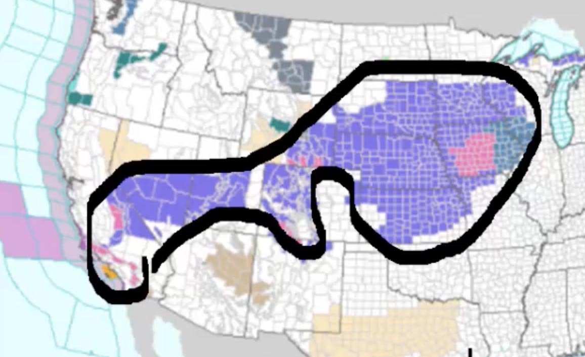
So perhaps there will be other opportunities coming. This is the National Weather Service map showing current advisories and watches and warnings when it comes to inclement weather, what I should want to show you here, especially if you’ve got travel plans or you know somebody traveling see all the pink and purple here.
All of these areas are under some type of Winter Weather Advisory or winter storm warning for today tonight into early tomorrow.
The entire state of Nebraska is under an advisory a lot of Kansas, a lot of Iowa, a lot of Minnesota, Wisconsin, a lot of Wyoming and the mountains of Colorado.
So you can see, especially in this area right here, this region is going to be impacted by this winter storm.
If you’re traveling or planning on traveling, if you haven’t left yet, you may just want to wait till the storm goes through because roads and highways are gonna get really icy this by our standards is not a big storm.
But it’s the most weather we’ve had in a while and it’s gonna bring just enough snow, cold and wind to make some poor travel conditions across the region.
This is where it is as of today, the low moving through Central and Southern California finally bringing that area some rain.
And this is a really good pattern for us to get snowed on. But what you’ll notice is, instead of it becoming what we call a closed low, a deep Colorado low, it’s going to just keep moving and become more of an open wave as it’s going to join up with this system coming in behind it. And what will happen by tomorrow.
This is by noon tomorrow. You can see it becomes an elongated trough really more of a frontal system that will head off to the east. And that’s going to keep it from becoming a really big storm. And then we’ve got another system diving in behind it now by Thursday noon.
Notice we’ve got a lo consolidating down here in South Texas and we have another wave coming in behind it. What is likely going to happen late this week is there’s gonna be a pretty big winter storm in the nation’s midsection as this guy gets kicked up.
So there’s going to be more travel concerns across the lower 48 states as we go to New Year’s Eve and as we go into New Year’s Day and you can see we’ve got another low backup here. Another low backup here.
It’s gonna stay really busy. Now this is the snowfall forecast through Thursday afternoon. And you can see this really shows where we are showing you those advisories where the snow is going to fall so you can see all of Interstate 80 is going to be impacted all of Nebraska’s it will be impacted all of Wyoming’s it will be impacted. I 25 along the front range of Wyoming in the Colorado will be impacted. I 70 the mountains of Colorado.
Gonna see a really nice shot of snow out of this. Look at the Wasatch. The winters of Utah going to see some pretty good snow with his system as well. And then the Pacific Northwest. He’s starting to see the next system coming on in later in the week. quick update on snowpacks. These have all gone up.
They’re still all below normal except these two drainages here. But a couple of weeks ago these were in the low to mid 60s right here. These were in the 60s and 70s. So we’re starting to see them in shop. They got a ways to go but they’re inching up and we’ll continue to see these snowpack figures.
Get a little bit better in the next couple of weeks, Colorado’s in a similar situation. These all right here, and right here, they’re gonna get some really good snow out of this storm system. So these numbers will be going up by the end of the week as well, long term. This is for Saturday Night of the upcoming New Year’s weekend.
We’ve got a pretty good front here. We’ve got other systems back up here, the Northwest flow is going to continue to move in. What this will do is this will keep us from having arctic air come in.
The Arctic air is still bottled up and it’s being held at bay. So no severe cold coming. But as long as this act of Jetstream comes in off the Pacific like this, these waves will keep coming through. So we’re basically going to have the same weather we’ve had wind events, mountain snow and occasionally some snow on the plains, but no slow moving storm.
This is by next Wednesday. You can see we got a wave coming through the middle of next week. Another one behind it. Here’s one here, here’s one here, so they’re just going to keep coming. So you’re going to see the heaviest precipitation falling in the mountains in this area here over the next week or two.
The Arctic oscillation we showed you this late last week. The Arctic oscillation all the way through January 12 remains in a negative phase and so with that negative phase, it’s going to stay an active weather pattern, but the focal point will be in the high country. Thanks for listening and watching the Day weather podcast.


