We’re already looking ahead and wondering when this summer winter storm is going to pass.
Wyoming’s weatherman Don Day says the weekend is going to be great. But until then, we have a big storm to work around.
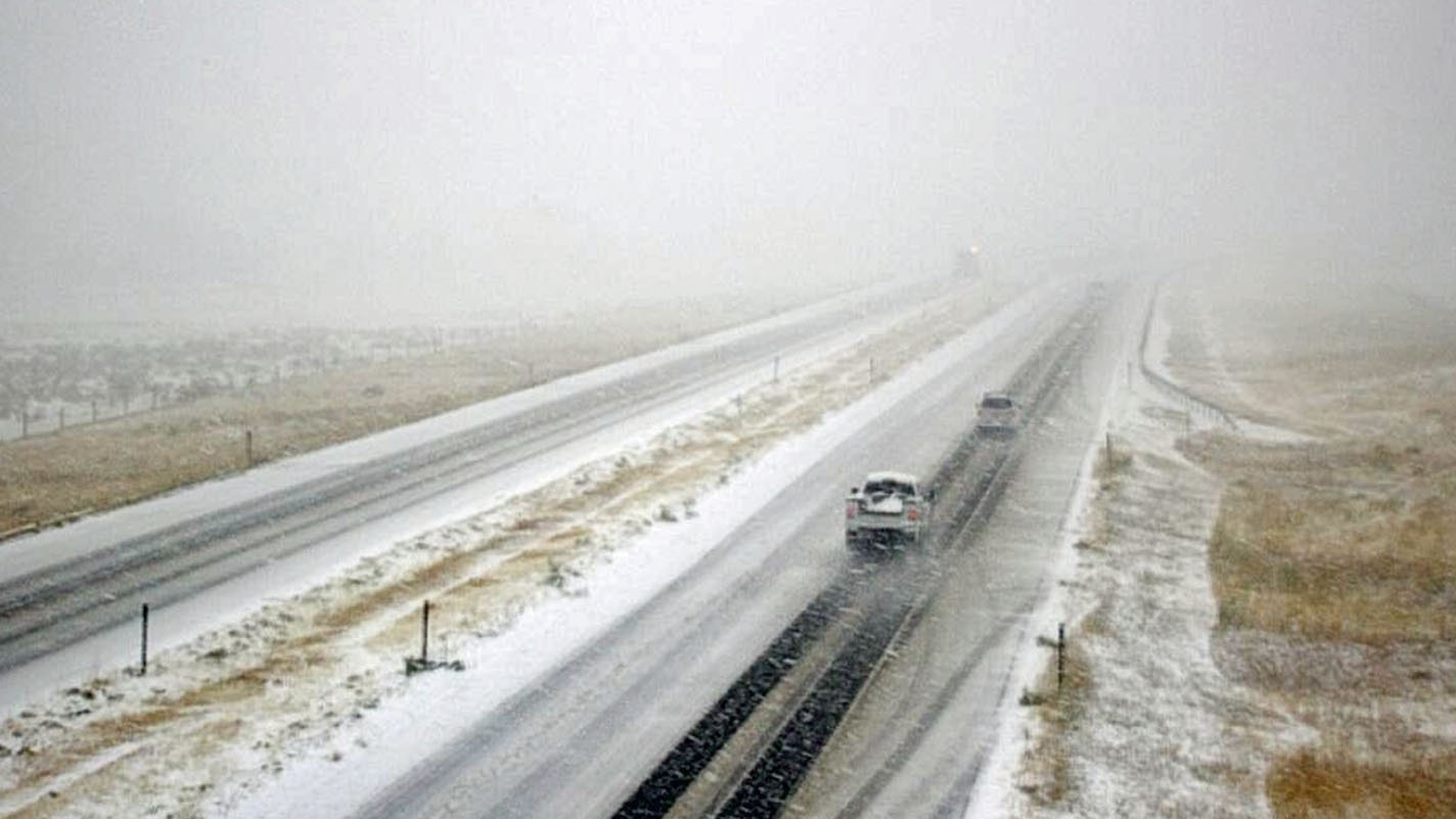
“When you look out your window in many areas here in the Rockies and the High Plains, the storm is going to impact the region through Friday. This is a doozy of a storm system folks for this early in the season,” Day said in his morning forecast.
Day said the storm doesn’t mean winter has arrived. This is just an “interruption,” he said.
“We’ve got nice fall weather coming but certainly it is fall now. This storm system is basically readjusting the jet stream and we’re still going to have some warm dry days coming up in September and October.”
Travel conditions will improve after early Wednesday, Day said.
And, although it may not seem that way, there is some good news that’s coming out of this moisture. It’s killing the fire season and will help with the drought.
“This is a godsend for the fires across the area,” Day said. “This is going to just do wonders with the fire situation. Especially the bad fire in the Front Range, the mountains west of Fort Collins. Look at all of that good moisture there.”
Wyoming will bounce back from this storm system but it’s going to take some time, Day said.
“Basically it’s going to stay very cool through Friday and we’ll see rain on the plains and snow showers in the high country. But by Saturday afternoon, we’ve got a nice high pressure Ridge returning to the region. It’s not a hot one.”
The following is a computer-generated transcript of the Don Day daily forecast. For best results, watch the video embedded above.
It’s Tuesday, September 8 2020, although you’d swear it’s November or December 8 2020. When you look at your window in many areas here in the Rockies and the High Plains, the storm is going to impact the region through Friday.
Folks, a lot of the biggest impacts are certainly coming through the next 24 hours. This is a doozy of a storm system folks for this early in the season. We’ll have travel impacts into early Wednesday, after early Wednesday. I think travel conditions will improve although it’s going to be slow going still over the higher elevations of it and this the mountain passes of the region.
Now this is a godsend for the fires that fire situation in Colorado, the Cameron Peak fire area blowing up over the weekend, causing widespread smoke across the Front Range, a huge increase in acreage that burned up but this is going to be a godsend the storm will for that fire and other fires burning in the West. And also the area’s most impacted by the real severe drought conditions this summer.
We’ll get good moisture out of the storm system. Now by the weekend, we’re right back to nice September weather again. This doesn’t mean we’re into winter folks, it’s an interruption. We’ve got nice fall weather coming but certainly it is fall now, after the storm system is basically readjusting the jetstream and we’re likely … still gonna have some real warm dry days coming up in September, October, we’ll have other fronts as well. But good weather will return by the weekend.
This is where we are today the big ridge in the Gulf of Alaska then the deep trough cutting into the United States. The upper level low over Utah is now bringing moisture into the region on top of the Arctic boundary that came into the region and is all away is even pushed west of the Continental Divide. So this is where we get overriding southwest winds over the cold air moisture getting lifted over the cold air. Great way to make it snow. The trajectory of the air follow the wind barbs …
Look how far … you wonder why it’s so cold because of the trajectory The air is coming all the way up basically from near the Arctic Circle folks. You wonder how things could change so quickly? Well over the weekend we had record heat come up from the deserts. And now we’ve actually completely done a 180 and bring it in from the Arctic.
This is our temperature relative to normal as of this morning. Look at the extent of this cold plunge You know, this cold plunge is going to go east and will affect other areas of the Corn Belt Midwest just not the Rockies and high plains but that is one impressive cold blast. This is the precipitation that will fall through the next three or four days.
Most of the heavier precipitation now is falling up in northern Wyoming and southern Montana but now it’s central and southern Wyoming, Colorado, New Mexico, the Western and high planes that are going to get a goodly amount of moisture, widespread moisture, the best we’ve seen in months in some areas, and you can see the yellow here the heavier precipitation in the mountains of Colorado, up into Wyoming.
This is going to just do wonders with the fire situation. Especially the bad fire in the Front Range, the mountains west of Fort Collins.
Look at all of that good moisture there. This is what temperatures are going to be like relative to average by tomorrow afternoon Denver 48 degrees below normal for temperatures by noon on Wednesday. That is one heck of a cold wave for this time of year. Look at this minus 30 degrees relative to normal going all the way through Amarillo and headed towards El Paso. Now let’s see what happens with the pattern.
This is for tomorrow morning. The upper level low barely moves. It just parks itself right along the Colorado-Utah line. High pressure stays in the Gulf of Alaska and the storm is gonna basically linger keeping us cold and wet well into the day on Wednesday. By Friday, look at that, it barely moves.
This is today. Two days later. It’s in East Central Wyoming. Now notice it’s not as strong. So what it will do is keep a cool moist, unstable airmass overhead. So basically it’s going to stay very cool through Friday and Wednesday through Friday will bring occasional showers of rain on the plains and snow showers to the high country, the region.
But by Saturday afternoon, we’ve got a nice high pressure ridge returning to the region. It’s not a hot one. But what it will do is bring a return of nice looking, in fact, great looking September weather by the weekend that will probably stretch into all the next week and this is by next Thursday and Friday.
A more zonal west to east flow goes across the country, so it’ll warm up. Now it won’t be terribly hot except here in California. The rest of the nation. This is really looking like a fall pattern with the jetstream, looking stronger, be more south towards the U.S. border.
Tropical activity showing up again, in a long, long range charts. Maybe from mid to late next week something to keep an eye on. Thanks for listening and watching to the Day weather podcast. Hopefully you can get through the storm. Okay, talk to you Wednesday.


