The following is a rushed transcript of Don Day’s Wyoming weather forecast. For best results, watch the video.
Don Day: In the short-term, the weather looks really, really good. It looks good through tomorrow and then it’s all downhill.
We have an arctic front that will be arriving in Montana by Friday night and in northern Wyoming by sunrise Saturday.
So enjoy the really good weather the next two days. Get outside if you need to do chores. Stockgrowers, take advantage of the next couple of days.
Then we’ve got this huge drop of temperatures with snow likely in most areas on Easter Sunday. It is going to snow in most of Wyoming Sunday.
Cold will persist for a week or more. Springs, folks I’m afraid to say, could be on hold until May.
The next two to three weeks, while there will be warm-ups, will be really short-lived.
Stockgrowers, I can’t stress strongly enough — our confidence is very high — take precautions, protect young and weak livestock really beginning in northern Wyoming Friday night and the entire night over the weekend.
And more bouts of snow will be developing next week.
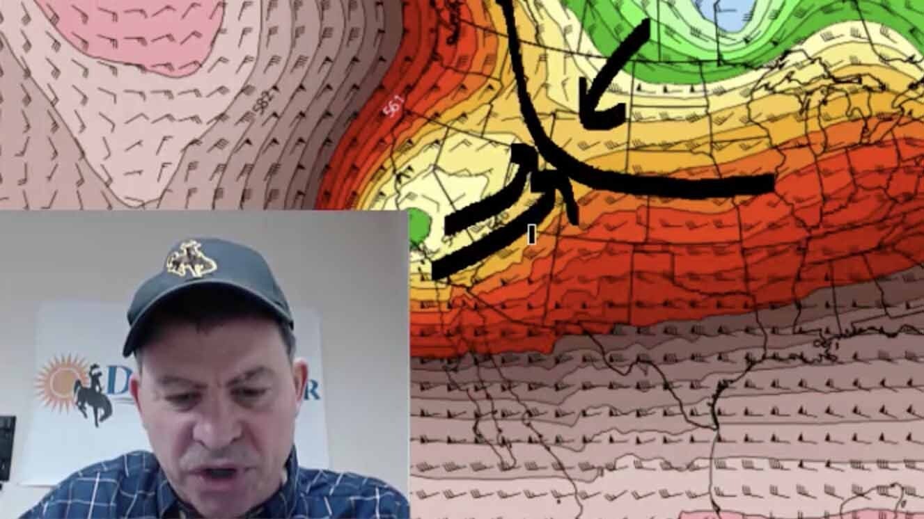
This is where we are going to be today with the jet stream pattern. The ridge is up in the Gulf of Alaska and the colder flow is staying off to our east.
We have southwest flow continuing ahead of that low out of California so we are enjoying this little sliver here of high pressure and warmer fair weather.
It is really going to be quite nice the next couple days.
However, by Saturday morning this low coming out of British Columbia is heading southeast.
Although it doesn’t look terribly impressive, this little kink in the jet stream is really driving a lot of what the weather will be.
You see all this blue up here — that is extremely cold air that is going to come south right into the heart of the rockies and the high plains.
That’s by Saturday morning. By Sunday afternoon, that British Columbia kink in the jet stream is right there.
There is another one right behind and another and then the Gulf of Alaska ridge is well-entrenched.
If you were to look at this and not see the date up here, you’d think it was something you’d see in January and February.
This is off the charts cold for April. By next Wednesday night and Thursday, there is another little ripple coming through.
So there is another snow event and another reenforcement of cold weather coming in the middle of next week.
Ten days out we see the flow flatten out a little bit. So late next week and next weekend, we may have a little bit of warm-up but here comes another one and here’s another one up here and the Gulf of Alaska ridge is basically maintaining itself.
That’s the problem, as long as the Gulf of Alaska ridge is up there, the door to Canada is up there.
Look at this. It is extremely cold air and it is on our side of the hemisphere. Over on the other side, it’s not nearly as cold.
The coldest air in the northern hemisphere is on our side for the next couple weeks.
So this guy, right here, is going to push fronts south and into the United States for the next couple weeks.
This is the precipitation outlook is thru Monday. This does not include what is coming in the middle of next week — there is another round of snow coming.
This pattern looks very similar to what you’ve seen all week during this podcast — the northwest to southeast flow.
A lot of these areas that are blue here will see a lot of snow. This is going to be mostly snow. It will start as rain but it won’t last long.
This is what snow will be like if we were to imagine the snow falling at 32 degrees — a 10 – 1 ratio. Pretty impressive as you can see.
Now with the air being really cold with this, we could use another formula. It is called ______ and it shows that we could have snow amounts that look like this thru Monday afternoon.
Kind of take the average between these two.
We are looking between 3 – 9 inches in the first ratio. The second ratio we’ve got bigger snow amounts.
The Bighorn Mountains in Wyoming is going to get clobbered. It will also bring significant snow to the Laramie range. It is going to bring heavy snow to Wyoming’s southern mountains.
This type of pattern is a big snow producer. Look at the Wind Rivers.
So the big snowpack basins are going to pick up a lot of water out of this pattern.
These are the forecasted low temperatures for Monday morning. There are in fahrenheit.
Anywhere where you see grey is below zero.
It is conceivable that we have pockets of sub-zero temperatures by Monday morning.
Single digits in most of central and eastern Wyoming.
This is a mid-winter type outbreak of cold. So for your Easter Egg hunt this year, looks like may want to be indoors.


