This is a rushed transcription of the Don Day weather forecast for Wednesday, March 18. For best results, watch the above video.
It’s Wednesday, March 18. Let’s take a look at the weather. The storm is still on track folks. We have seen a lot of consistency in most of the computer modeling.
The models we trust the most have been extremely consistent in showing us the developing storm tonight and Thursday across northeastern Colorado.
Confidence remains high. We are going to see this as being a relatively small storm in geographical scales. It won’t cover as much ground as we have seen other March storms do.
But where it will impact will be high. There is a big gradient in terms of who gets snow and who doesn’t.
Depending on whether you are watching this podcast, you could be under a blizzard warning or nothing at all.
Blizzard conditions are likely on Thursday and Thursday night for southeastern Wyoming. This will lead to dangerous travel and livestock conditions.
Travel will be very difficult on Thursday through Friday morning in many areas of Wyoming and parts of Colorado and Nebraska as well.
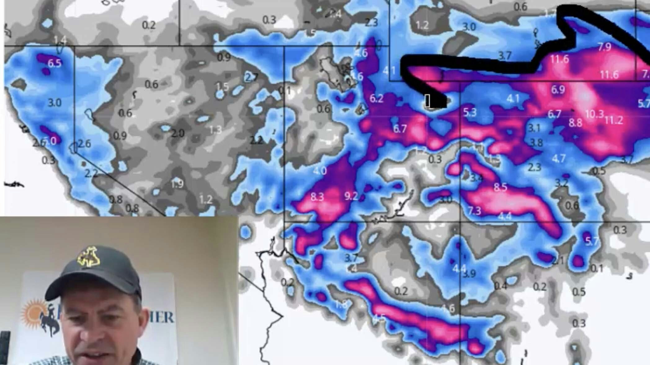
This is the updated forecast of precipitation totals. This is what we call liquid. If you were to measure this as if it fell as rain. You can see the blue and the yellow and orange colored areas.
Anywhere you see yellow, you are looking at over an inch of liquid water. Anything that is blue or darker is a half-inch to 3/4 of an inch.
This is the area here that will have the heaviest of precipitation.
If you have been watching this week, the maps have been very consistent at showing the heaviest precipitation along this east/west axis across southeastern Wyoming.
We have also seen a real increase here in the available moisture for northeastern Colorado including Colorado’s northern front range.
Notice the big gradient. You go to almost nothing north of Casper and almost nothing south of I-70. It is a rather narrow area of where the heaviest precipitation is going to fall.
This is the area right here where we are having the most concern in terms of really core winter conditions and travel conditions and livestock conditions.
Let’s convert this to snow. This is what we see using a 10-1 ratio. This may be a situation where these amounts that you see here may be somewhat underdone in some areas.
But there is a swath of snow that goes right underneath the band of precipitation with the higher elevations, you are really noticing the pink. These are areas that are above 7,000/8,000 feet and higher.
You also notice significant snows along the Colorado front range and the I-25 corridor and the I-80 corridor of Wyoming.
Let’s focus in on the same map I showed you so you can see the snowfalls total I showed you earlier. These are 10-1 ratios. We may see some of these amounts higher.
One area in particular area — northern Laramie County, southern Goshen county, southern Platte county. There is some higher ground here — higher terrain — where the northeast upslope winds may enhance the snowfall amounts.
I would not be surprised right here — there are many areas that could receive a foot of snow. A foot of snow in the Laramie range. Between Laramie and Cheyenne is a good bet. Snowy Range. The mountains of northern Colorado really showing a lot of snowfall as well with this storm system.
The wind is a problem. This is why we have a blizzard warning in effect. These are forecasted wind gusts by noon tomorrow.
By noon tomorrow, we will have winds gusting 30-40mph and this combined with all this snow I showed you, will cause a lot of blowing and drifting, zero visibilities at times, and those blizzard conditions.
Also, there is going to be some strong winds here along Interstate 80. The snow won’t be as heavy, the wind will cause a lot of blowing snow and difficult travel conditions.
Then we have the next storm system of interest. This is a forecast map for next Wednesday. We have a low here, a low here, a low here, and a low here.
None of these look terribly big, we have a lot of weather coming in off the Pacific and will move into western U.S.
We will see more action with the weather in the next 7 days. First things first is focusing on the storm in the short-term.


