The following is a rushed transcript of today’s Don Day weather forecast. For best results, watch video.
It is Friday, February 28. Good morning.
Well, we’ve got an extra day. It’s Leap Day. So we have a bonus day — not only an extra day of the year, but an extra good day of weather before here comes March. Coming in a bit like a lion on Sunday and Monday.
Today and tomorrow is a great opportunity to travel or do something outside. Going to be spring-like. 40s and 50s today. 50s and 60s tomorrow. Really a couple of good days.
However, if you’ve got plans to travel or be outdoors Sunday into Monday, well heads-up to stockgrowers and travelers, wintry weather returns.
This is why. There is a low coming in. This is the forecast by late Sunday night in to Monday morning.
We have a low pressure in southern California which feeds energy and moisture this way. Then we have this little kink in the jet stream — that is a Canadian cold front which will bring in colder Canadian air.
When you take Pacific moisture from here. You bring in Canadian air from here and you put these areas together, this is always a good pattern to make it snow.
We have a lot of confidence in this pattern that you’re going to get snow. It doesn’t tend to produce a ton of snow.
This also is the type of storm system that doesn’t produce a ton of wind either. So it is more of a straight-down snow which doesn’t happen often.
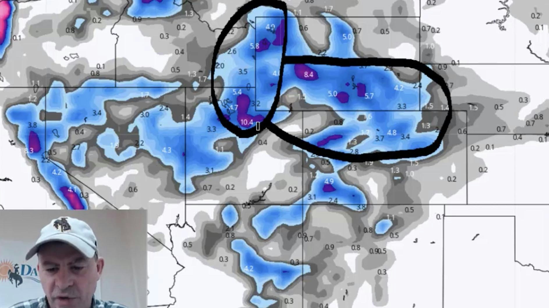
But it’s going to be covering a lot of real estate. This is the prediction through Tuesday morning of where the heaviest snow will fall.
Remember, this is a model. The thing to remember models is that they are tools, not reality.
But it is a good way to show you where we think the heaviest snow will fall. And as you can see, all of the I-80 corridor of Wyoming and western Nebraska, we’re going to get snowed on.
So if you have travels on I-80 starting late Saturday night and into Sunday morning here, you are going to run into snowfall. This is an area to watch out for Saturday night and Sunday morning.
Then you can see Casper, along I-25 and out into the front range of Colorado will all be impacted. Also, watch out for this bullseye. This is a Lander/South Pass system. This type of system really does bring heavy snow to the South Pass of Wyoming and that will be something to watch out for.
See these purple areas here on the higher terrain between Rawlins and Laramie — that is the Snow Chi Minh trail. I-80 corridor area that will significant snow.
Again, this starts on Saturday night late in this area and during the overnight hours of Saturday spreads into Central Wyoming and the southern areas of the state during the day Sunday into Monday morning. Be ready for some wintry weather after two really good looking days.
Now, after that storm system moves out, this is for Thursday. Notice we get a westerly flow. That means warmer temperatures that will come in.
What will happen is, this is the roller coaster season. We have a winter event. We get colder after a couple warm days. Then we have a nice warmup at the end of next weekend.
Although the next system will come in the following Saturday and Sunday and it could bring cold and snow again. We’ll see.
This pattern right here in the Pacific is a little conveluted. This area of low pressure here and this area of low pressure here, it may not be handled well by the models.
Do expect the weather forecast to be variable or changeable. Typical for this time of year.
Snowpack conditions. They continue to be very good. Only the Sweetwater and the Belle Fourche drainages are a bit below average right now, the rest of Wyoming is doing very well. Same for Colorado.
One quick thing I want to show you. This is a very long range forecast for August, September, and October. These are sea temperature forecasts.
This is something that we’ll update you on in the coming weeks and months. As we continue to see the computer modeling forecasting cold sea surface temperatures in the sub tropical Pacific which means late summer / early fall we could enter into a la Nina phase, that means a dry signature.
Be ready for some great weather for a couple days. Then be ready for snow Saturday night through early Monday.