The following is a rushed transcription of Don Day’s weather forecast for February 14 and the President’s Day weekend.
Good morning. Hello everyone. Happy Valentine’s Day. Thanks for watching the Day Weather podcast.
It’s all about the wind over the next couple days. Today and Saturday. Winds are going to be picking up. Especially true for viewers in Wyoming where I-80 and I-25 will be hit by high winds, blowover risks, blowing and drifting snow and out in the open areas along secondary roads.
It will definitely be a concern.
As we take a look past the next two days, which generally speaking for today and Saturday, other than mountain snow showers, looks fairly dry.
But we do see another weather system that will bring snow back into Wyoming late Saturday but especially into Sunday.
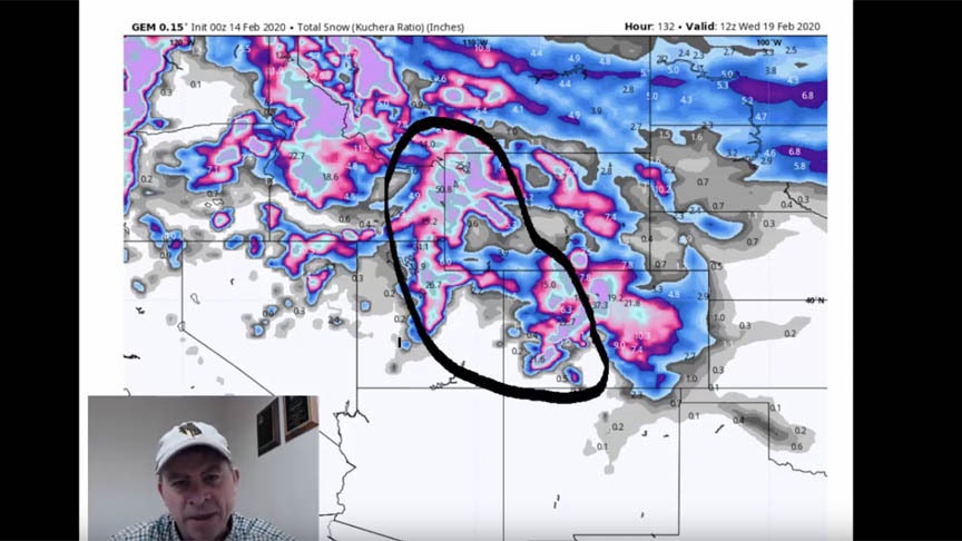
As we get into Sunday and President’s Day Monday, this is the snow forecast. Notice we have snow in all of the mountain ranges and the Rockies. But also we will see the possibility that we will see snow east of the Continental Divide Sunday night but especially Monday into Tuesday.
Also there is going to be snow near the mountains along the western slopes of Wyoming, Colorado, and into the Wasatch front of Utah as well.
As we have seen for most of the several weeks, the mountains have really gotten the bulk of the snow. That will continue.
But since this is a three day weekend, just a heads-up along I-80, I-25, I-90, there will be some wintry weather on Sunday night into Monday.
So if you have a three day weekend, keep that in mind. It’s not a big storm but enough to be a nuisance.
And there is a lot of cold air that’s going to come in and make Sunday night, Monday, and Tuesday quite a bit colder all throughout this region for the first half of next week.
Warmer, windy today and Saturday. Then Sunday and Sunday night, Monday, and Tuesday be ready for some wintry weather again.
We are anticipating late next week a warmup. I think as we get into the following weekend, there could be a thaw. The first half of next week looks pretty cold. Late next week and next weekend a thaw.
But after that, things get interesting again.
This is a very long range outlook. This takes us all the way out to Tuesday, Feb 25. One thing that’s showing up on the modeling is a large low coming into the Four Corners region sometime around Feb 24, 25, 26.
Will this happen? It’s a question mark. But we are seeing signs that this scenario which would be a weather producer is on the table. We talked earlier this week that March could be an active month and it kinda gets started in February. That still looks to be the case.
One thing that I want to show and we pay attention to at Day Weather is sea-surface temperatures. This is a sea surface temperature map of the globe.
Anywhere you see blue, water temperatures are a little cold. Orange and red is a little bit warmer.
These are temperatures relative to what we call averages. Where the cold and warm water is is really important.
Remember how stormy last Spring was. We had that big blizzard last winter in the middle of March. We went into March with one of the busier and stormier Marchs in awhile.
And a lot of that had to do with what the sea surface temperatures were.
This is our current sea surface temperature patterns right now. I want to show you this relative warmth. This is not an El Nino but relative warmth right here north of the equator.
We still have temperatures in the Pacific that are a little bit warmer than average.
This area of colder weather is growing and it could result in La Nina later this year.
But check out the remarkable similarities in the sea surface temperatures in the middle of February to where we were a year ago.
A year ago today, this is what they look like. This is what they look like now.
A year ago, it was a little bit colder in the Indian Ocean. We also have the same coolness developing here.
But this relative area of warmth right here and right here is very similar to where we were a year ago.
So the table is set late February into March that this warmer water temperature — again not very warm but just warm enough — to add more energy and moisture into the west United States in the beginning of March and the end of February.
we’ll keep you up to date on these sea surface temperatures occasionally.
Thanks for watching the Day Weather podcast. Have a great weekend. Talk to you on Monday.


