The following is a transcription of Don Day’s weather forecast for Thursday, February 13.
A pleasant and good Thursday everybody. Thanks for listening and watching the Day Weather podcast.
Let’s take a look at what’s coming over the next few days. We did some snow last night. A couple of inches in Cheyenne and Laramie and Casper got some snow. Central and northeast Wyoming too.
That system is moving out. As we get into today, quiet and cold today. Good news is that we don’t expect much wind. Just a good old fashioned cold February day.
As the snow flurries will be coming to an end today. The problem is what we have for Friday and Saturday.
Outside of mountain snow showers, it will be generally dry. But here’s the issue, we’ve got the wind picking up and this is going to be a problem for travelers.
Look at the wind picking up along I-25 and I-80 and the gap areas of northern Colorado and southern Wyoming’s mountain areas.
We are going to have some blowing snow Friday along I-25 and along I-80 as we get into tomorrow and tomorrow night the winds will pick up in the Shirley Basin / Casper area as well.
If you have to travel, as we get into Friday and Saturday, the I-80 corridor and along I-25 will be something to watch for.
However, for today, Friday, and Saturday, other than snow showers over near the mountains, we’re looking for quiet weather.
The next weather event coming our way is something we need to watch for President’s Day weekend.
During the day Sunday, we will see snow break out across Wyoming’s western mountains. We have a storm that will swing in from the Pacific Northwest.
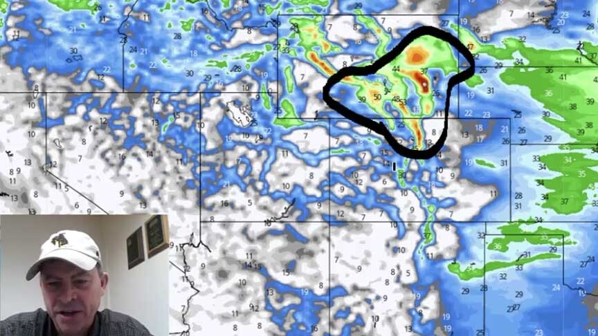
As we get into Sunday night and Monday, we are going to see snow and you see it right here, the model will have it coming out on the plains.
We are going to have to watch out — especially in this area here for possibly some accumulating snowfall. Doesn’t look like a big storm but I do think the model might be underplaying the snow possibilities right here as we get into Sunday night and Monday.
We’ve got tomorrow to update you.
Bottom line is: good weather today. Be ready for the wind Friday and Saturday. Then late Sunday and President’s Day, here comes the next chance of snow. And it looks pretty cold again.
Thanks for watching the Day Weather podcast. Talk to you on Friday.