UPDATE (1:30 PM): The US National Weather Service Cheyenne Wyoming has just issued a blizzard warning, in effect from noon Wednesday to 3 PM Thursday, for large parts of southeast Wyoming:
“Blizzard conditions are expected with total snow accumulations of 6 to 13 inches and winds gusting as high as 55 mph,” according to the NWS warning. “Travel could be very difficult. Areas of blowing snow could significantly reduce visibility. Roads will be slick. The hazardous conditions could impact the morning or evening commute.”
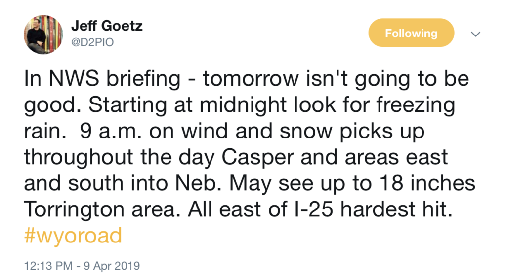
Wyoming Department of Transportation public information officer Jeff Goetz tweeted the following guidance for Wyoming travelers in eastern Wyoming:
Will continue to update this story as we get new information. Stay tuned for the latest.
Wyoming braced for another shot of winter-like weather as a storm warning went into effect for most of the eastern third of the state in anticipation of a weather system expected to hit by Wednesday.
The National Weather Service issued a winter storm warning for an area from Cheyenne and Laramie north to Gillette and Sheridan, along with a winter storm watch for most of the rest of the state, in advance of the storm expected to bring up to 5 inches of snow to southern Wyoming and 12 inches to the area around Lusk.
While the storm was not expected to be as severe as the blizzard that shut down much of eastern Wyoming in mid-March, it was predicted to bring heavy, wet snow to the area.
“It’s not quite as strong as the storm on March 13, but it will still pack quite a punch,” said Meteorologist Steve Rubin. “There will be less snow, but it should be more of a wet snow.”
Forecasts called for snow to begin falling in eastern Wyoming by midday Wednesday and continue through Thursday.
Accumulations were predicted to range from 3 to 5 inches in Cheyenne and 5 to 11 inches in Douglas and Gillette to up to 12 inches in Lusk.
Snow was expected to fall across most of the rest of the state by Wednesday, but heavy snowfall was predicted only in the mountains outside of eastern Wyoming.
After the storm, the National Weather Service said conditions would improve, with temperatures rising to the 50s by Sunday.
“It’s going to take a few days to warm up,” Rubin said. “It will be a slow warming trend, but it should melt off some of the snow.”